

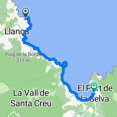
Port de la Selva, Cala Taballera, Cadaqués
A cycling route starting in Llançà, Catalonia, Spain.
Overview
About this route
Ruta per Alt Empodà, sortint de Port de la Selva i per cala Taballera fins Cadaqués. La tornda per Perafita.
- -:--
- Duration
- 39.8 km
- Distance
- 828 m
- Ascent
- 829 m
- Descent
- ---
- Avg. speed
- ---
- Avg. speed

Continue with Bikemap
Use, edit, or download this cycling route
You would like to ride Port de la Selva, Cala Taballera, Cadaqués or customize it for your own trip? Here is what you can do with this Bikemap route:
Free features
- Save this route as favorite or in collections
- Copy & plan your own version of this route
- Sync your route with Garmin or Wahoo
Premium features
Free trial for 3 days, or one-time payment. More about Bikemap Premium.
- Navigate this route on iOS & Android
- Export a GPX / KML file of this route
- Create your custom printout (try it for free)
- Download this route for offline navigation
Discover more Premium features.
Get Bikemap PremiumFrom our community
Other popular routes starting in Llançà
 transpirenaica 2005
- Distance
- 815.4 km
- Ascent
- 6,623 m
- Descent
- 6,620 m
- Location
- Llançà, Catalonia, Spain
 GR92_2. Tag 13.05.19
- Distance
- 20.2 km
- Ascent
- 429 m
- Descent
- 431 m
- Location
- Llançà, Catalonia, Spain
 Transpyrenees 2020
- Distance
- 785.5 km
- Ascent
- 28,587 m
- Descent
- 28,597 m
- Location
- Llançà, Catalonia, Spain
 Day 1. 2nd stretch. Port de la Selva - Llançà
- Distance
- 8.6 km
- Ascent
- 78 m
- Descent
- 84 m
- Location
- Llançà, Catalonia, Spain
 Llança, St. Pere de Rodes
- Distance
- 35.7 km
- Ascent
- 920 m
- Descent
- 921 m
- Location
- Llançà, Catalonia, Spain
 Ruta larga MTB: Port de la Selva - Cadaquès - Port de la Selva
- Distance
- 37.3 km
- Ascent
- 1,058 m
- Descent
- 1,058 m
- Location
- Llançà, Catalonia, Spain
 Milloret del cap de creus (cadaqués
- Distance
- 78.9 km
- Ascent
- 1,259 m
- Descent
- 1,250 m
- Location
- Llançà, Catalonia, Spain
 Port de la Selva, Cala Taballera, Cadaqués
- Distance
- 39.8 km
- Ascent
- 859 m
- Descent
- 859 m
- Location
- Llançà, Catalonia, Spain
Open it in the app