
Panoramastrasse am Monte Baldo
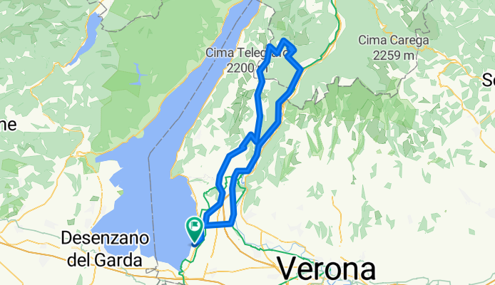
A cycling route starting in Colà, Veneto, Italy.
Overview
About this route
Klassiker am Lago: Hinauf zum Monte Baldo Gipfel warten mehr als 2000 Höhenmeter. Die schönste und kurvigste Variante führt von Aivio im Etschtal zur Bocca del Creer. Tipp: nicht am höchsten Punkt rasten, sonder nach kurzer Abfahrt an der Bocca di Navene. An der Scharte (Mit Gasthaus) toller Tiefblick auf den Lago.
- -:--
- Duration
- 104.6 km
- Distance
- 1,826 m
- Ascent
- 1,826 m
- Descent
- ---
- Avg. speed
- ---
- Avg. speed

Route quality
Waytypes & surfaces along the route
Waytypes
Busy road
66.3 km
(63 %)
Road
31.7 km
(30 %)
Surfaces
Paved
101.3 km
(97 %)
Asphalt
101.3 km
(97 %)
Paving stones
0 km
(<1 %)
Undefined
3.3 km
(3 %)
Continue with Bikemap
Use, edit, or download this cycling route
You would like to ride Panoramastrasse am Monte Baldo or customize it for your own trip? Here is what you can do with this Bikemap route:
Free features
- Save this route as favorite or in collections
- Copy & plan your own version of this route
- Sync your route with Garmin or Wahoo
Premium features
Free trial for 3 days, or one-time payment. More about Bikemap Premium.
- Navigate this route on iOS & Android
- Export a GPX / KML file of this route
- Create your custom printout (try it for free)
- Download this route for offline navigation
Discover more Premium features.
Get Bikemap PremiumFrom our community
Other popular routes starting in Colà
 Pacengo - Valpolocella - Verona - Pacengo
- Distance
- 61.9 km
- Ascent
- 255 m
- Descent
- 256 m
- Location
- Colà, Veneto, Italy
 Lazise nach Valeggio und zurück
- Distance
- 40.3 km
- Ascent
- 219 m
- Descent
- 223 m
- Location
- Colà, Veneto, Italy
 Lazise nach Sirmione und zurück
- Distance
- 44.4 km
- Ascent
- 376 m
- Descent
- 395 m
- Location
- Colà, Veneto, Italy
 Aufnahme vom 14.05.2016, 17:31
- Distance
- 6.5 km
- Ascent
- 46 m
- Descent
- 45 m
- Location
- Colà, Veneto, Italy
 Lange Ausfahrt durch Lazise
- Distance
- 34.3 km
- Ascent
- 255 m
- Descent
- 254 m
- Location
- Colà, Veneto, Italy
 Pacengo Sandrà Custoza Lungomincio
- Distance
- 46.8 km
- Ascent
- 229 m
- Descent
- 229 m
- Location
- Colà, Veneto, Italy
 Pacengo - Garda - Costermano - San Zeno - Caprino Veronese - Affi - Pacengo
- Distance
- 58.3 km
- Ascent
- 721 m
- Descent
- 721 m
- Location
- Colà, Veneto, Italy
 Rundtour Lazise
- Distance
- 58.3 km
- Ascent
- 779 m
- Descent
- 779 m
- Location
- Colà, Veneto, Italy
Open it in the app