

Tour16: Ravi
A cycling route starting in Massa Marittima, Tuscany, Italy.
Overview
About this route
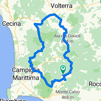
Routenbeschrieb: Wir fahren vorbei am Lago dell' Accesa zur Häusergruppe bei der Station von Gavorrano. Von hier aus folgen wir ein kurzes Stück weit der SS N.1. Von hier führt uns die Strasse weiter den Hang entlang abfallend und zum Teil wieder ziemlich steil ansteigend über Ravi nach Caldana und wieder hinungter zur SS N.1, der wir nur ganz kurz folgen bis zum Aufsteig nach Giuncarico. Nach der von hier aus folgenden Abfahrt erholen wir uns noch etwas auf den nächsten ziemlich flachen 11km über Ribolla nach Collacchina, wo der ca. 18km lange und über 500 Hphenmeter aufweisende Aufstieb über Tatti nach Prata beginnt. Dieser Aufstieg ist ausser im Dorf Tatti nirgends besonders steil. Von Prata aus nehmen wir zum Schluss die kuvenreiche Abfahrt nach MassaVecchia in Angriff.
Aufgefallen: Diese Tour führt uns in einige auf Bergvorsprüngen gebaute Dörfer und ist mit einer vielfältigen Aussicht auf dei landschaft in dieser Gegend verbunden.- -:--
- Duration
- 70.3 km
- Distance
- 732 m
- Ascent
- 731 m
- Descent
- ---
- Avg. speed
- ---
- Avg. speed

Route quality
Waytypes & surfaces along the route
Waytypes
Busy road
48.8 km
(69 %)
Road
17.2 km
(25 %)
Surfaces
Paved
18.5 km
(26 %)
Unpaved
2.6 km
(4 %)
Asphalt
18.5 km
(26 %)
Gravel
2.4 km
(3 %)
Continue with Bikemap
Use, edit, or download this cycling route
You would like to ride Tour16: Ravi or customize it for your own trip? Here is what you can do with this Bikemap route:
Free features
- Save this route as favorite or in collections
- Copy & plan your own version of this route
- Sync your route with Garmin or Wahoo
Premium features
Free trial for 3 days, or one-time payment. More about Bikemap Premium.
- Navigate this route on iOS & Android
- Export a GPX / KML file of this route
- Create your custom printout (try it for free)
- Download this route for offline navigation
Discover more Premium features.
Get Bikemap PremiumFrom our community
Other popular routes starting in Massa Marittima
 toscana
- Distance
- 31.5 km
- Ascent
- 362 m
- Descent
- 359 m
- Location
- Massa Marittima, Tuscany, Italy
 MASSA LAPESTA
- Distance
- 29.2 km
- Ascent
- 502 m
- Descent
- 493 m
- Location
- Massa Marittima, Tuscany, Italy
 MTB 31 km HalbtagestourMaremma
- Distance
- 31.2 km
- Ascent
- 438 m
- Descent
- 438 m
- Location
- Massa Marittima, Tuscany, Italy
 03a Castiglione della Pescaia
- Distance
- 59.3 km
- Ascent
- 692 m
- Descent
- 868 m
- Location
- Massa Marittima, Tuscany, Italy
 massa tour
- Distance
- 26.5 km
- Ascent
- 608 m
- Descent
- 608 m
- Location
- Massa Marittima, Tuscany, Italy
 Massa-Marittima Cicalino
- Distance
- 117 km
- Ascent
- 1,444 m
- Descent
- 1,388 m
- Location
- Massa Marittima, Tuscany, Italy
 Rundtour Massa-Marittima
- Distance
- 148.2 km
- Ascent
- 2,625 m
- Descent
- 2,680 m
- Location
- Massa Marittima, Tuscany, Italy
 8 - MTB - Cross Country - Blue - Tour Massa Marittima
- Distance
- 31.4 km
- Ascent
- 513 m
- Descent
- 502 m
- Location
- Massa Marittima, Tuscany, Italy
Open it in the app