
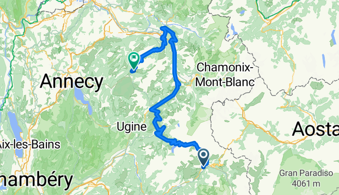
2009 Tour de France Stage 17
A cycling route starting in Bourg-Saint-Maurice, Auvergne-Rhône-Alpes, France.
Overview
About this route
- -:--
- Duration
- 161.6 km
- Distance
- 3,860 m
- Ascent
- 3,758 m
- Descent
- ---
- Avg. speed
- ---
- Avg. speed

Route highlights
Points of interest along the route
Point of interest after 20.1 km
Cormet de Roselend
Point of interest after 28.3 km
Col de Meraillet
Point of interest after 59.1 km
Col des Saisies
Point of interest after 100.1 km
Col de Pierre Carrée
Point of interest after 110.8 km
Cote d'Araches
Point of interest after 135.1 km
Col de Romme
Point of interest after 149.3 km
Col de la Colombière
Continue with Bikemap
Use, edit, or download this cycling route
You would like to ride 2009 Tour de France Stage 17 or customize it for your own trip? Here is what you can do with this Bikemap route:
Free features
- Save this route as favorite or in collections
- Copy & plan your own version of this route
- Sync your route with Garmin or Wahoo
Premium features
Free trial for 3 days, or one-time payment. More about Bikemap Premium.
- Navigate this route on iOS & Android
- Export a GPX / KML file of this route
- Create your custom printout (try it for free)
- Download this route for offline navigation
Discover more Premium features.
Get Bikemap PremiumFrom our community
Other popular routes starting in Bourg-Saint-Maurice
 Tour de France 2009, Etappe 17 - 169,5 km
- Distance
- 169.5 km
- Ascent
- 3,968 m
- Descent
- 3,968 m
- Location
- Bourg-Saint-Maurice, Auvergne-Rhône-Alpes, France
 Day 4 BSM to Geneva
- Distance
- 145.1 km
- Ascent
- 1,847 m
- Descent
- 2,283 m
- Location
- Bourg-Saint-Maurice, Auvergne-Rhône-Alpes, France
 2017 ALPS ETAPA 1 - Iseran-savonne
- Distance
- 110.9 km
- Ascent
- 2,717 m
- Descent
- 2,720 m
- Location
- Bourg-Saint-Maurice, Auvergne-Rhône-Alpes, France
 Tag 7
Tag 7- Distance
- 122.8 km
- Ascent
- 2,011 m
- Descent
- 2,107 m
- Location
- Bourg-Saint-Maurice, Auvergne-Rhône-Alpes, France
 RdGA - Stage 3 (Var. Mont Cenis finish Moncenisio)
- Distance
- 112.4 km
- Ascent
- 2,791 m
- Descent
- 2,173 m
- Location
- Bourg-Saint-Maurice, Auvergne-Rhône-Alpes, France
 2017 ALPS Col de l'Iseran a
- Distance
- 147.7 km
- Ascent
- 3,138 m
- Descent
- 3,138 m
- Location
- Bourg-Saint-Maurice, Auvergne-Rhône-Alpes, France
 04 Bourg-Saint-Maurice - Aosta
- Distance
- 82.1 km
- Ascent
- 10,333 m
- Descent
- 11,300 m
- Location
- Bourg-Saint-Maurice, Auvergne-Rhône-Alpes, France
 Bourg St.Maurice-Col d´Izeran-St Etienne de Cuines-Col de la Madeleine-La Lechere
- Distance
- 189.9 km
- Ascent
- 3,543 m
- Descent
- 3,918 m
- Location
- Bourg-Saint-Maurice, Auvergne-Rhône-Alpes, France
Open it in the app