

Bauernbadradelroute
A cycling route starting in Bünde, North Rhine-Westphalia, Germany.
Overview
About this route
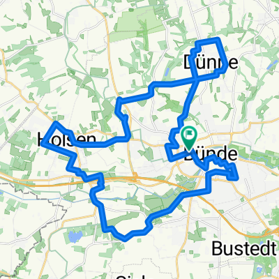
Die Bauernbad-Radelroute ist ein Rundkurs von 37 <span class="abbr" title="Kilometer">km</span> Länge.<br /> Der Startpunkt ist die Radstation Bünde am Bahnhof.<br /> In Randringhausen ist der Tourenbeginn ebenfalls gut möglich, da sich die Route dort auf dem Hin- und Rückweg trifft und in eine Nordschleife (24 <span style="color:#0000ff;"><span class="abbr" title="Kilometer">km</span></span>) und eine Südschleife (13 <span style="color:#0000ff;"><span class="abbr" title="Kilometer">km</span></span>) teilt.<br /> Kurhaus Ernstmeier und Kurhaus Wilmsmeier sowie die Pensionen Helenenhof und Quellental sind mit ihren Restaurants und Cafés durchgehend geöffnet und bieten Parkmöglichkeiten für den Einstieg in die Rundtour.
- -:--
- Duration
- 36.6 km
- Distance
- 273 m
- Ascent
- 273 m
- Descent
- ---
- Avg. speed
- ---
- Avg. speed

Route quality
Waytypes & surfaces along the route
Waytypes
Quiet road
24.9 km
(68 %)
Busy road
3.6 km
(10 %)
Surfaces
Paved
29.7 km
(81 %)
Unpaved
0 km
(<1 %)
Asphalt
27 km
(74 %)
Paving stones
1.9 km
(5 %)
Continue with Bikemap
Use, edit, or download this cycling route
You would like to ride Bauernbadradelroute or customize it for your own trip? Here is what you can do with this Bikemap route:
Free features
- Save this route as favorite or in collections
- Copy & plan your own version of this route
- Sync your route with Garmin or Wahoo
Premium features
Free trial for 3 days, or one-time payment. More about Bikemap Premium.
- Navigate this route on iOS & Android
- Export a GPX / KML file of this route
- Create your custom printout (try it for free)
- Download this route for offline navigation
Discover more Premium features.
Get Bikemap PremiumFrom our community
Other popular routes starting in Bünde
 Montag
- Distance
- 32.8 km
- Ascent
- 140 m
- Descent
- 140 m
- Location
- Bünde, North Rhine-Westphalia, Germany
 Bünde-Löhne Schützenstraße
- Distance
- 10.5 km
- Ascent
- 13 m
- Descent
- 30 m
- Location
- Bünde, North Rhine-Westphalia, Germany
 Miteinander 2014 - Hücker Aschen
- Distance
- 17.9 km
- Ascent
- 59 m
- Descent
- 59 m
- Location
- Bünde, North Rhine-Westphalia, Germany
 CVJM-KV-Radtour 2016
- Distance
- 43 km
- Ascent
- 185 m
- Descent
- 185 m
- Location
- Bünde, North Rhine-Westphalia, Germany
 Tabak-Radelroute
- Distance
- 28.8 km
- Ascent
- 162 m
- Descent
- 155 m
- Location
- Bünde, North Rhine-Westphalia, Germany
 Von der Radstation zur Birnenallee
- Distance
- 22.7 km
- Ascent
- 204 m
- Descent
- 212 m
- Location
- Bünde, North Rhine-Westphalia, Germany
 Tabak-Radelroute
- Distance
- 28.9 km
- Ascent
- 149 m
- Descent
- 147 m
- Location
- Bünde, North Rhine-Westphalia, Germany
 Von Bünde bis Wangerland
- Distance
- 221.5 km
- Ascent
- 534 m
- Descent
- 609 m
- Location
- Bünde, North Rhine-Westphalia, Germany
Open it in the app