

Dwusetka
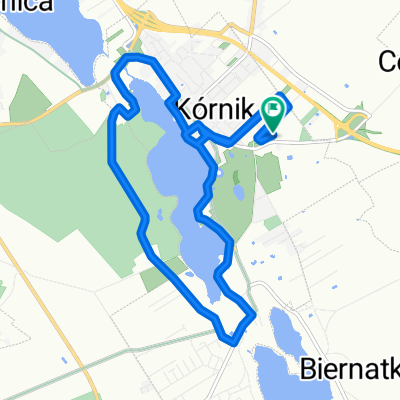
A cycling route starting in Kórnik, Greater Poland Voivodeship, Poland.
Overview
About this route
Na próbę po pałacach Wielkopolski.
1. Kórnik 3 km 2. Rogalin 16 km 3. Będlewo 32 km 4. Racot 57 km 5. Drzeczkowo 76 km 6. Rydzyna 96 km 7. Pawłowice 107 km 8. Rokosowo 121 km 9. Pudliszki 124 km 10. Krobia 128 km 11. Gębice 137 km 12. Pępowo 140 km - -:--
- Duration
- 204.1 km
- Distance
- 233 m
- Ascent
- 233 m
- Descent
- ---
- Avg. speed
- ---
- Avg. speed

Route quality
Waytypes & surfaces along the route
Waytypes
Road
89.2 km
(44 %)
Busy road
48.2 km
(24 %)
Surfaces
Paved
145.6 km
(71 %)
Unpaved
2.7 km
(1 %)
Asphalt
133.8 km
(66 %)
Paving stones
7.2 km
(4 %)
Continue with Bikemap
Use, edit, or download this cycling route
You would like to ride Dwusetka or customize it for your own trip? Here is what you can do with this Bikemap route:
Free features
- Save this route as favorite or in collections
- Copy & plan your own version of this route
- Sync your route with Garmin or Wahoo
Premium features
Free trial for 3 days, or one-time payment. More about Bikemap Premium.
- Navigate this route on iOS & Android
- Export a GPX / KML file of this route
- Create your custom printout (try it for free)
- Download this route for offline navigation
Discover more Premium features.
Get Bikemap PremiumFrom our community
Other popular routes starting in Kórnik
 Osiedle Ignacego Krasickiego 7, Kórnik do Osiedle Ignacego Krasickiego, Kórnik
- Distance
- 43.3 km
- Ascent
- 279 m
- Descent
- 280 m
- Location
- Kórnik, Greater Poland Voivodeship, Poland
 Almost Springtime
- Distance
- 28.8 km
- Ascent
- 39 m
- Descent
- 36 m
- Location
- Kórnik, Greater Poland Voivodeship, Poland
 Sobotnie otwarcie
- Distance
- 17.8 km
- Ascent
- 32 m
- Descent
- 33 m
- Location
- Kórnik, Greater Poland Voivodeship, Poland
 KÓRNICKI PIERŚCIEŃ ROWEROWY
- Distance
- 55.1 km
- Ascent
- 97 m
- Descent
- 97 m
- Location
- Kórnik, Greater Poland Voivodeship, Poland
 Powolna trasa w Kórnik
- Distance
- 12 km
- Ascent
- 73 m
- Descent
- 72 m
- Location
- Kórnik, Greater Poland Voivodeship, Poland
 Poznańska 77, Kórnik do Romana Maya 127A, Poznań
- Distance
- 20 km
- Ascent
- 129 m
- Descent
- 130 m
- Location
- Kórnik, Greater Poland Voivodeship, Poland
 Kórnik - Zaniemyśl - Czmoniec
- Distance
- 55.2 km
- Ascent
- 97 m
- Descent
- 97 m
- Location
- Kórnik, Greater Poland Voivodeship, Poland
 Kórnik-Zaniemyśl-Środa-Śródka-Kórnik
- Distance
- 55.7 km
- Ascent
- 65 m
- Descent
- 65 m
- Location
- Kórnik, Greater Poland Voivodeship, Poland
Open it in the app