

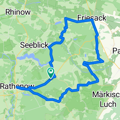
Friesacker Bier und Bammer Äpfel
A cycling route starting in Nennhausen, Brandenburg, Germany.
Overview
About this route
Mostly tarmac
- -:--
- Duration
- 74.3 km
- Distance
- 160 m
- Ascent
- 160 m
- Descent
- ---
- Avg. speed
- ---
- Avg. speed
Route quality
Waytypes & surfaces along the route
Waytypes
Busy road
29 km
(39 %)
Quiet road
17.6 km
(24 %)
Surfaces
Paved
62 km
(83 %)
Unpaved
4.9 km
(7 %)
Asphalt
50.8 km
(68 %)
Concrete
7.7 km
(10 %)
Continue with Bikemap
Use, edit, or download this cycling route
You would like to ride Friesacker Bier und Bammer Äpfel or customize it for your own trip? Here is what you can do with this Bikemap route:
Free features
- Save this route as favorite or in collections
- Copy & plan your own version of this route
- Sync your route with Garmin or Wahoo
Premium features
Free trial for 3 days, or one-time payment. More about Bikemap Premium.
- Navigate this route on iOS & Android
- Export a GPX / KML file of this route
- Create your custom printout (try it for free)
- Download this route for offline navigation
Discover more Premium features.
Get Bikemap PremiumFrom our community
Other popular routes starting in Nennhausen
 Friesacker Bier und Bammer Äpfel
- Distance
- 74.3 km
- Ascent
- 160 m
- Descent
- 160 m
- Location
- Nennhausen, Brandenburg, Germany
 Großtrappentour
- Distance
- 39.4 km
- Ascent
- 80 m
- Descent
- 80 m
- Location
- Nennhausen, Brandenburg, Germany
 Ride 2022-03-22
- Distance
- 48 km
- Ascent
- 182 m
- Descent
- 176 m
- Location
- Nennhausen, Brandenburg, Germany
 Fontane.Rad Hauptroute - 5. Etappe
- Distance
- 9 km
- Ascent
- 65 m
- Descent
- 59 m
- Location
- Nennhausen, Brandenburg, Germany
 Döberitzer Straße 21, Nennhausen nach Breite Straße 41B, Nennhausen
- Distance
- 15.5 km
- Ascent
- 51 m
- Descent
- 48 m
- Location
- Nennhausen, Brandenburg, Germany
 Nennhausen-Paulinenaue-Neuruppin
- Distance
- 56 km
- Ascent
- 100 m
- Descent
- 91 m
- Location
- Nennhausen, Brandenburg, Germany
 1. Tag
- Distance
- 63.4 km
- Ascent
- 326 m
- Descent
- 312 m
- Location
- Nennhausen, Brandenburg, Germany
 Stahlbergring nach Lindenstraße
- Distance
- 44.5 km
- Ascent
- 107 m
- Descent
- 101 m
- Location
- Nennhausen, Brandenburg, Germany
Open it in the app