
5 Länder - nach Pula (Kroatien)
A cycling route starting in Rosenheim, Bavaria, Germany.
Overview
About this route
<div class="routedescription " style="margin-top: 0px; margin-right: 0px; margin-bottom: 15px; margin-left: 0px; padding-top: 0px; padding-right: 0px; padding-bottom: 0px; padding-left: 0px; border-top-width: 0px; border-right-width: 0px; border-bottom-width: 0px; border-left-width: 0px; border-style: initial; border-color: initial; border-image: initial; outline-width: 0px; outline-style: initial; outline-color: initial; height: auto; overflow-x: hidden; overflow-y: hidden; color: rgb(102, 102, 102); font-family: Helvetica, 'Helvetica Neue', Arial, sans-serif; line-height: 20px; ">
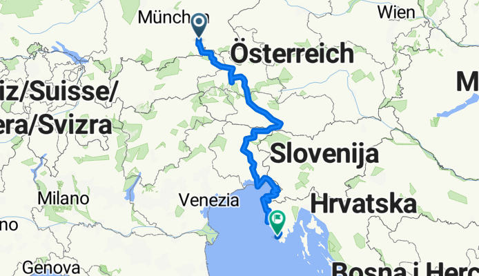
Die Route führt vom Inntal zum Walchsee, dann nach Zell am See über Badgastein (Bahntunnel) nach Villach und von dort westlich nach Udine an die Küstenstraße bis hinunter nach Pula. Am interessantesten ist das Stück zwischen Villach und Udine. Je weiter man in den italienischen Teil der Alpen hineinfährt, desto zahlreicher werden Brücken und Tunnel. An der Küste gibt es nur spärlich Radwege, aber dafür zahlreiche Campingplätze und sehr schöne Strände zum verweilen. Besonders kurz vor Trieste ( Sistiana) und in Novigrad lohnt es sich eine Nacht zu verbringen. ACHTUNG zwischendurch wurden Streckenabschnitte nicht getrackt. Meist ist der Radweg aber ausgeschildert. Nur bei den Alpenausläufern vor Udine sollte man die Augen offen halten,teilweise sind dort keine Zeichen mehr.In Rosenheim sollte man so früh wie möglich auf den Inntalradweg! </div>
<br /> <br />
- -:--
- Duration
- 711.5 km
- Distance
- 2,599 m
- Ascent
- 3,029 m
- Descent
- ---
- Avg. speed
- ---
- Avg. speed
Route quality
Waytypes & surfaces along the route
Waytypes
Busy road
189.6 km
(27 %)
Quiet road
158.3 km
(22 %)
Surfaces
Paved
500.2 km
(70 %)
Unpaved
86 km
(12 %)
Asphalt
472 km
(66 %)
Gravel
53.1 km
(7 %)
Continue with Bikemap
Use, edit, or download this cycling route
You would like to ride 5 Länder - nach Pula (Kroatien) or customize it for your own trip? Here is what you can do with this Bikemap route:
Free features
- Save this route as favorite or in collections
- Copy & plan your own version of this route
- Sync your route with Garmin or Wahoo
Premium features
Free trial for 3 days, or one-time payment. More about Bikemap Premium.
- Navigate this route on iOS & Android
- Export a GPX / KML file of this route
- Create your custom printout (try it for free)
- Download this route for offline navigation
Discover more Premium features.
Get Bikemap PremiumFrom our community
Other popular routes starting in Rosenheim
 Oberland-Irschenberg Runde
- Distance
- 105.4 km
- Ascent
- 500 m
- Descent
- 500 m
- Location
- Rosenheim, Bavaria, Germany
 Radeln rund um Rosenheim - SUR Radweg (Große Tour)
- Distance
- 89.6 km
- Ascent
- 483 m
- Descent
- 482 m
- Location
- Rosenheim, Bavaria, Germany
 Im Winter um den Simsee.
- Distance
- 44.9 km
- Ascent
- 181 m
- Descent
- 181 m
- Location
- Rosenheim, Bavaria, Germany
 Radeln rund um Rosenheim - SUR Radweg (Rundweg Nord)
- Distance
- 36.5 km
- Ascent
- 131 m
- Descent
- 130 m
- Location
- Rosenheim, Bavaria, Germany
 Die schönsten Straßen im Chiemgau 1
- Distance
- 61.2 km
- Ascent
- 908 m
- Descent
- 908 m
- Location
- Rosenheim, Bavaria, Germany
 Hofstätter- Rinssee Runde
- Distance
- 31 km
- Ascent
- 203 m
- Descent
- 202 m
- Location
- Rosenheim, Bavaria, Germany
 Ultimative Transalp - Tour de France
- Distance
- 496.7 km
- Ascent
- 1,033 m
- Descent
- 1,476 m
- Location
- Rosenheim, Bavaria, Germany
 Erweiterte Chiemseerunde
- Distance
- 98.8 km
- Ascent
- 580 m
- Descent
- 517 m
- Location
- Rosenheim, Bavaria, Germany
Open it in the app