
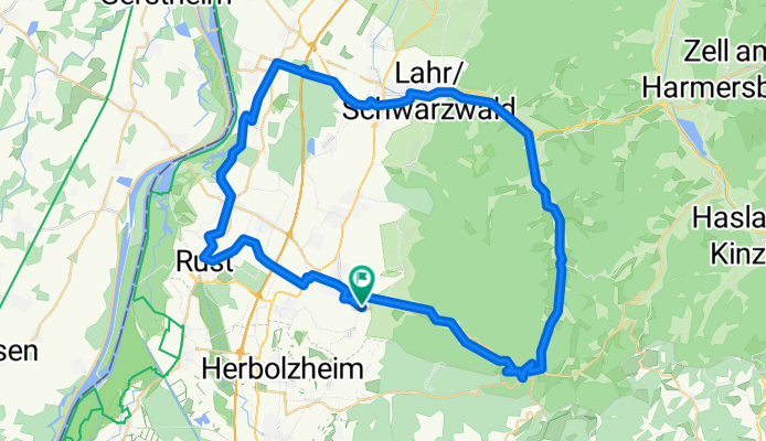
Landelin Tour (Nr. 20)
A cycling route starting in Ettenheim, Baden-Württemberg, Germany.
Overview
About this route
Radeln Sie auf den Spuren des heiligen St. Landelin, der aus dem heutigen Irland stammte und dessen Einsatz für die Verbreitung des christlichen Glaubens ihn in das heutige Ettenheimmünster<br /> geführt hat.
Start und Ziel: Campingplatz, Mühlenweg Quelle: Tourismus Ortenau- -:--
- Duration
- 62.5 km
- Distance
- 328 m
- Ascent
- 330 m
- Descent
- ---
- Avg. speed
- ---
- Avg. speed

Route quality
Waytypes & surfaces along the route
Waytypes
Track
20.3 km
(32 %)
Quiet road
19.1 km
(31 %)
Surfaces
Paved
48.4 km
(77 %)
Unpaved
11 km
(18 %)
Asphalt
42.6 km
(68 %)
Gravel
6.1 km
(10 %)
Continue with Bikemap
Use, edit, or download this cycling route
You would like to ride Landelin Tour (Nr. 20) or customize it for your own trip? Here is what you can do with this Bikemap route:
Free features
- Save this route as favorite or in collections
- Copy & plan your own version of this route
- Sync your route with Garmin or Wahoo
Premium features
Free trial for 3 days, or one-time payment. More about Bikemap Premium.
- Navigate this route on iOS & Android
- Export a GPX / KML file of this route
- Create your custom printout (try it for free)
- Download this route for offline navigation
Discover more Premium features.
Get Bikemap PremiumFrom our community
Other popular routes starting in Ettenheim
 Ettenheim_kleine_Abendrunde_im_Wald
- Distance
- 14.5 km
- Ascent
- 373 m
- Descent
- 371 m
- Location
- Ettenheim, Baden-Württemberg, Germany
 Kleine Herausforderung für den Sonntag
- Distance
- 90.4 km
- Ascent
- 1,883 m
- Descent
- 1,705 m
- Location
- Ettenheim, Baden-Württemberg, Germany
 zur Kirnburg - grandioser Ausblick
- Distance
- 23.9 km
- Ascent
- 452 m
- Descent
- 449 m
- Location
- Ettenheim, Baden-Württemberg, Germany
 Haselstaude - Windradweg
- Distance
- 24.2 km
- Ascent
- 441 m
- Descent
- 441 m
- Location
- Ettenheim, Baden-Württemberg, Germany
 Kirnburg Variante II
- Distance
- 28.9 km
- Ascent
- 515 m
- Descent
- 512 m
- Location
- Ettenheim, Baden-Württemberg, Germany
 Ettenheim-Heimbach-Teningen-Ettenheim
- Distance
- 43.7 km
- Ascent
- 257 m
- Descent
- 250 m
- Location
- Ettenheim, Baden-Württemberg, Germany
 Gerade Fahrt in Ettenheim
- Distance
- 17.3 km
- Ascent
- 275 m
- Descent
- 277 m
- Location
- Ettenheim, Baden-Württemberg, Germany
 Ettenheim_Sulz_Langenhard_Ettenheim_25km
- Distance
- 26 km
- Ascent
- 526 m
- Descent
- 527 m
- Location
- Ettenheim, Baden-Württemberg, Germany
Open it in the app