
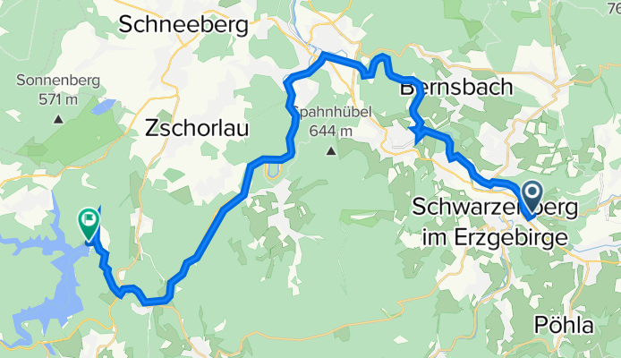
Schwarzenberg - Talsperre Eibenstock
A cycling route starting in Schwarzenberg, Saxony, Germany.
Overview
About this route
Für das Erzgebirge relativ flache Tour über geteerte Radwege und unbefestigte Waldwege. Von Aue bis Wolfsgrün fahren wir auf dem neu gebauten Radweg. Das letzte Stück geht auf der Straße zur Talsperre. Dort ist auch eine Einkehrmöglichkeit.
Geeignet für Trekking- und Mountainbikes sowie E-Bikes.<div style="left: -1000px; top: 12px; width: 1px; height: 1px; overflow: hidden; position: absolute;"> </div> <div style="left: -1000px; top: 12px; width: 1px; height: 1px; overflow: hidden; position: absolute;"> </div>
- -:--
- Duration
- 27.9 km
- Distance
- 452 m
- Ascent
- 285 m
- Descent
- ---
- Avg. speed
- ---
- Avg. speed
Route quality
Waytypes & surfaces along the route
Waytypes
Cycleway
15.3 km
(55 %)
Quiet road
5.6 km
(20 %)
Surfaces
Paved
24.5 km
(88 %)
Unpaved
1.8 km
(6 %)
Asphalt
24.2 km
(87 %)
Gravel
1.8 km
(6 %)
Route highlights
Points of interest along the route
Point of interest after 2.1 km
Rittergut Sachsenfeld erbaut ca.1593 ehemals Pension und Gaststätte
Point of interest after 3.9 km
Hammerbrücke erbaut 1732 komplett aus Holz Länge 21,5m Breite 3m Grundsaniert 1992
Point of interest after 10.5 km
Hochwasserschutz Aue Renaturierung und Schaffung von Überflutungsflächen
Point of interest after 12.2 km
Nicolaikirche Aue erbaut 1625-1628, 1885 abgerissen und am 27.07.1891 fand die Grundsteinlegung der heutigen Kirche statt, diese besteht aus roten Backstein.
Point of interest after 15.3 km
Alte Bahnstrecke zwischen Aue und Neidhardtsthal 07.09.1875 eröffnet, 1975 durch den Bau der Talsperre Eibenstock unterbrochen. Am 31.12.1994 endete auch der Güterverkehr zwischen Aue und Wolfsgrün.
Point of interest after 16.6 km
Der Bockauer Tunnel, Länge 296 Meter Erbaut 05.04.1873 Tunneldurchbruch März 1874 300 Bauarbeiter waren am Bau beteiligt 400 000 Mark hat der Bau damals gekostet
Continue with Bikemap
Use, edit, or download this cycling route
You would like to ride Schwarzenberg - Talsperre Eibenstock or customize it for your own trip? Here is what you can do with this Bikemap route:
Free features
- Save this route as favorite or in collections
- Copy & plan your own version of this route
- Sync your route with Garmin or Wahoo
Premium features
Free trial for 3 days, or one-time payment. More about Bikemap Premium.
- Navigate this route on iOS & Android
- Export a GPX / KML file of this route
- Create your custom printout (try it for free)
- Download this route for offline navigation
Discover more Premium features.
Get Bikemap PremiumFrom our community
Other popular routes starting in Schwarzenberg
 E Bike RT Fichtelberg
- Distance
- 50 km
- Ascent
- 891 m
- Descent
- 888 m
- Location
- Schwarzenberg, Saxony, Germany
 rund ums Jägerhaus
- Distance
- 22.7 km
- Ascent
- 445 m
- Descent
- 445 m
- Location
- Schwarzenberg, Saxony, Germany
 1. Freitagstour 2015
- Distance
- 28.4 km
- Ascent
- 383 m
- Descent
- 383 m
- Location
- Schwarzenberg, Saxony, Germany
 Auersberg
- Distance
- 48.3 km
- Ascent
- 1,189 m
- Descent
- 1,176 m
- Location
- Schwarzenberg, Saxony, Germany
 20150503_101036.gpx
- Distance
- 55.7 km
- Ascent
- 621 m
- Descent
- 695 m
- Location
- Schwarzenberg, Saxony, Germany
 Schwarzenberg -> SW Anstieg -> Fichtelberg -> Oberwiesenthal -> Neudorf -> Scheibenberg -> Schw.bg.
- Distance
- 60.4 km
- Ascent
- 980 m
- Descent
- 976 m
- Location
- Schwarzenberg, Saxony, Germany
 Auffahrt Szb - Beierfeld /Spiegelwald
- Distance
- 3.9 km
- Ascent
- 253 m
- Descent
- 0 m
- Location
- Schwarzenberg, Saxony, Germany
 Schwarzenber-Elterlein-Emmler-Schwarzenberg
- Distance
- 27.5 km
- Ascent
- 395 m
- Descent
- 396 m
- Location
- Schwarzenberg, Saxony, Germany
Open it in the app