

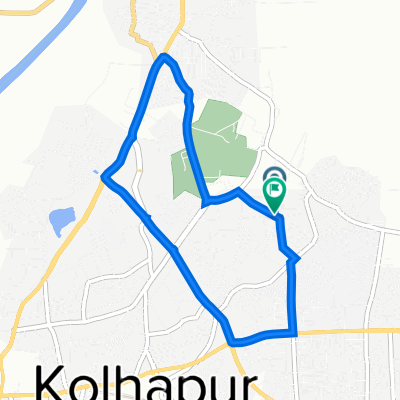
KOP to GOA via Ajra Amboli
A cycling route starting in Kolhāpur, Maharashtra, India.
Overview
About this route
KOP to GOA
- -:--
- Duration
- 193.9 km
- Distance
- 853 m
- Ascent
- 1,431 m
- Descent
- ---
- Avg. speed
- ---
- Max. altitude
Continue with Bikemap
Use, edit, or download this cycling route
You would like to ride KOP to GOA via Ajra Amboli or customize it for your own trip? Here is what you can do with this Bikemap route:
Free features
- Save this route as favorite or in collections
- Copy & plan your own version of this route
- Split it into stages to create a multi-day tour
- Sync your route with Garmin or Wahoo
Premium features
Free trial for 3 days, or one-time payment. More about Bikemap Premium.
- Navigate this route on iOS & Android
- Export a GPX / KML file of this route
- Create your custom printout (try it for free)
- Download this route for offline navigation
Discover more Premium features.
Get Bikemap PremiumFrom our community
Other popular routes starting in Kolhāpur
 Kolhapur to Karad
- Distance
- 74.5 km
- Ascent
- 198 m
- Descent
- 214 m
- Location
- Kolhāpur, Maharashtra, India
 Wadanage-Kolhapur Road to Wadanage-Kolhapur Road
- Distance
- 21.8 km
- Ascent
- 386 m
- Descent
- 420 m
- Location
- Kolhāpur, Maharashtra, India
 KOP-Devgad Beach
- Distance
- 131.5 km
- Ascent
- 396 m
- Descent
- 947 m
- Location
- Kolhāpur, Maharashtra, India
 morning ride
- Distance
- 7.2 km
- Ascent
- 41 m
- Descent
- 39 m
- Location
- Kolhāpur, Maharashtra, India
 Slow ride
- Distance
- 12.3 km
- Ascent
- 190 m
- Descent
- 87 m
- Location
- Kolhāpur, Maharashtra, India
 Salokhe Nagar Road 37, Kolhapur to Salokhe Nagar Road 37, Kolhapur
- Distance
- 17.6 km
- Ascent
- 16 m
- Descent
- 28 m
- Location
- Kolhāpur, Maharashtra, India
 katyayani (15 Feb 2021)
- Distance
- 20.6 km
- Ascent
- 161 m
- Descent
- 146 m
- Location
- Kolhāpur, Maharashtra, India
 Nerli bridge
- Distance
- 17.3 km
- Ascent
- 253 m
- Descent
- 256 m
- Location
- Kolhāpur, Maharashtra, India
Open it in the app