
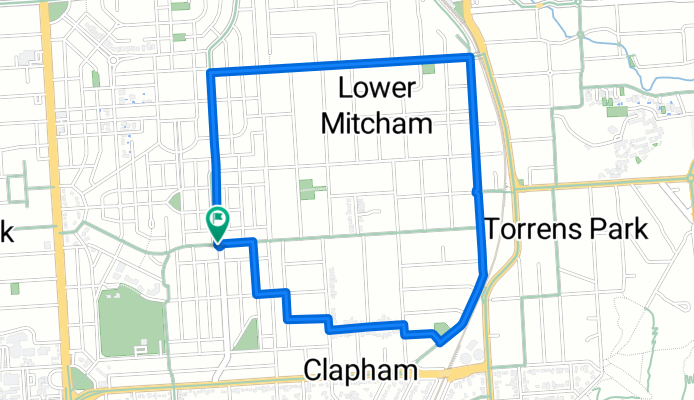
Colonel Light Gardens/Clapham Loop
A cycling route starting in Clapham, South Australia, Australia.
Overview
About this route
Go up a nice hilly bit and then down a nice smooth road where you can pick up some speed.
- -:--
- Duration
- 4.1 km
- Distance
- 41 m
- Ascent
- 38 m
- Descent
- ---
- Avg. speed
- ---
- Avg. speed
Route quality
Waytypes & surfaces along the route
Waytypes
Road
2.2 km
(54 %)
Quiet road
1.9 km
(46 %)
Surfaces
Paved
4.1 km
(100 %)
Asphalt
3.9 km
(95 %)
Paved (undefined)
0.2 km
(5 %)
Undefined
0 km
(<1 %)
Continue with Bikemap
Use, edit, or download this cycling route
You would like to ride Colonel Light Gardens/Clapham Loop or customize it for your own trip? Here is what you can do with this Bikemap route:
Free features
- Save this route as favorite or in collections
- Copy & plan your own version of this route
- Sync your route with Garmin or Wahoo
Premium features
Free trial for 3 days, or one-time payment. More about Bikemap Premium.
- Navigate this route on iOS & Android
- Export a GPX / KML file of this route
- Create your custom printout (try it for free)
- Download this route for offline navigation
Discover more Premium features.
Get Bikemap PremiumFrom our community
Other popular routes starting in Clapham
 Leigh street
- Distance
- 9.2 km
- Ascent
- 52 m
- Descent
- 117 m
- Location
- Clapham, South Australia, Australia
 Windy Point
- Distance
- 3.8 km
- Ascent
- 259 m
- Descent
- 81 m
- Location
- Clapham, South Australia, Australia
 Fitness test
- Distance
- 1.6 km
- Ascent
- 134 m
- Descent
- 7 m
- Location
- Clapham, South Australia, Australia
 Cheeky Sunday Spin
- Distance
- 55.2 km
- Ascent
- 837 m
- Descent
- 834 m
- Location
- Clapham, South Australia, Australia
 adlaide ca 30 km
- Distance
- 15.8 km
- Ascent
- 485 m
- Descent
- 231 m
- Location
- Clapham, South Australia, Australia
 Mylor Lofty Norton
- Distance
- 76.9 km
- Ascent
- 1,043 m
- Descent
- 1,042 m
- Location
- Clapham, South Australia, Australia
 Uraidla via Norton
- Distance
- 29 km
- Ascent
- 547 m
- Descent
- 138 m
- Location
- Clapham, South Australia, Australia
 Route check. Lynton>Belair NPark>Sheoak Rd return>Windy point DH trail>Lynton
- Distance
- 18.7 km
- Ascent
- 457 m
- Descent
- 457 m
- Location
- Clapham, South Australia, Australia
Open it in the app