

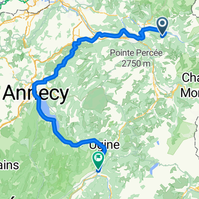
Col de Pierre Carrée
A cycling route starting in Arâches-la-Frasse, Auvergne-Rhône-Alpes, France.
Overview
About this route
Great Winter climb. 1844 metres at summit
- -:--
- Duration
- 46.1 km
- Distance
- 1,444 m
- Ascent
- 1,444 m
- Descent
- ---
- Avg. speed
- ---
- Avg. speed

Route quality
Waytypes & surfaces along the route
Waytypes
Busy road
45.4 km
(98 %)
Quiet road
0.3 km
(<1 %)
Surfaces
Paved
42.3 km
(92 %)
Unpaved
0.1 km
(<1 %)
Asphalt
42.1 km
(91 %)
Concrete
0.2 km
(<1 %)
Continue with Bikemap
Use, edit, or download this cycling route
You would like to ride Col de Pierre Carrée or customize it for your own trip? Here is what you can do with this Bikemap route:
Free features
- Save this route as favorite or in collections
- Copy & plan your own version of this route
- Sync your route with Garmin or Wahoo
Premium features
Free trial for 3 days, or one-time payment. More about Bikemap Premium.
- Navigate this route on iOS & Android
- Export a GPX / KML file of this route
- Create your custom printout (try it for free)
- Download this route for offline navigation
Discover more Premium features.
Get Bikemap PremiumFrom our community
Other popular routes starting in Arâches-la-Frasse
 Above Faine Col Hunting
- Distance
- 23.4 km
- Ascent
- 1,123 m
- Descent
- 1,126 m
- Location
- Arâches-la-Frasse, Auvergne-Rhône-Alpes, France
 Annecy - Plateau des Saix
- Distance
- 211.9 km
- Ascent
- 4,407 m
- Descent
- 5,761 m
- Location
- Arâches-la-Frasse, Auvergne-Rhône-Alpes, France
 Gravel Arraches
- Distance
- 46.3 km
- Ascent
- 1,579 m
- Descent
- 1,581 m
- Location
- Arâches-la-Frasse, Auvergne-Rhône-Alpes, France
 Col de Pierre Carrée (Flaine)
- Distance
- 41.9 km
- Ascent
- 1,359 m
- Descent
- 1,363 m
- Location
- Arâches-la-Frasse, Auvergne-Rhône-Alpes, France
 Chalet - Como Stage 1
- Distance
- 119.4 km
- Ascent
- 737 m
- Descent
- 1,306 m
- Location
- Arâches-la-Frasse, Auvergne-Rhône-Alpes, France
 Chemin de la Digue, Magland à Quai de la Liberté, Cluses
- Distance
- 7.8 km
- Ascent
- 59 m
- Descent
- 62 m
- Location
- Arâches-la-Frasse, Auvergne-Rhône-Alpes, France
 Col de Pierre Carrée (Flaine ski station)
- Distance
- 49.9 km
- Ascent
- 1,572 m
- Descent
- 1,570 m
- Location
- Arâches-la-Frasse, Auvergne-Rhône-Alpes, France
 Flaine
- Distance
- 45.4 km
- Ascent
- 1,364 m
- Descent
- 1,365 m
- Location
- Arâches-la-Frasse, Auvergne-Rhône-Alpes, France
Open it in the app