

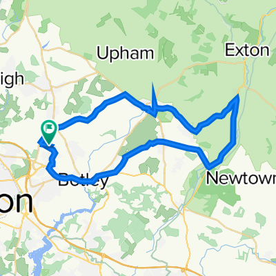
Denmead Loop
A cycling route starting in Hedge End, England, United Kingdom.
Overview
About this route
Denmead Loop
- -:--
- Duration
- 50.7 km
- Distance
- 323 m
- Ascent
- 325 m
- Descent
- ---
- Avg. speed
- ---
- Avg. speed
Route quality
Waytypes & surfaces along the route
Waytypes
Busy road
33.4 km
(66 %)
Road
12.2 km
(24 %)
Surfaces
Paved
31.6 km
(62 %)
Unpaved
0 km
(<1 %)
Asphalt
27.5 km
(54 %)
Paved (undefined)
4.1 km
(8 %)
Continue with Bikemap
Use, edit, or download this cycling route
You would like to ride Denmead Loop or customize it for your own trip? Here is what you can do with this Bikemap route:
Free features
- Save this route as favorite or in collections
- Copy & plan your own version of this route
- Sync your route with Garmin or Wahoo
Premium features
Free trial for 3 days, or one-time payment. More about Bikemap Premium.
- Navigate this route on iOS & Android
- Export a GPX / KML file of this route
- Create your custom printout (try it for free)
- Download this route for offline navigation
Discover more Premium features.
Get Bikemap PremiumFrom our community
Other popular routes starting in Hedge End
 Curdridge curcuit
- Distance
- 34.9 km
- Ascent
- 191 m
- Descent
- 191 m
- Location
- Hedge End, England, United Kingdom
 Ian - 18 Hensting
- Distance
- 28.9 km
- Ascent
- 190 m
- Descent
- 187 m
- Location
- Hedge End, England, United Kingdom
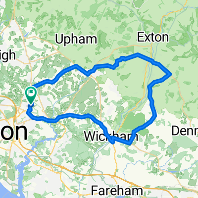
 Wickham Corhampton Fair Oak 25
- Distance
- 40.7 km
- Ascent
- 209 m
- Descent
- 210 m
- Location
- Hedge End, England, United Kingdom
 Ian - 18 Netley Chartwell Green
- Distance
- 29.3 km
- Ascent
- 143 m
- Descent
- 143 m
- Location
- Hedge End, England, United Kingdom
 Denmead Loop
- Distance
- 50.7 km
- Ascent
- 323 m
- Descent
- 325 m
- Location
- Hedge End, England, United Kingdom
 24 Soberton
- Distance
- 40.5 km
- Ascent
- 264 m
- Descent
- 264 m
- Location
- Hedge End, England, United Kingdom
 18 - Fishers Pond Waltham Chase
- Distance
- 28.1 km
- Ascent
- 151 m
- Descent
- 151 m
- Location
- Hedge End, England, United Kingdom
 Moderate route in Southampton
- Distance
- 7.3 km
- Ascent
- 55 m
- Descent
- 56 m
- Location
- Hedge End, England, United Kingdom
Open it in the app