
Kitzbüheler Alpen Rundtour Tag 1
A cycling route starting in Wörgl, Tyrol, Austria.
Overview
About this route
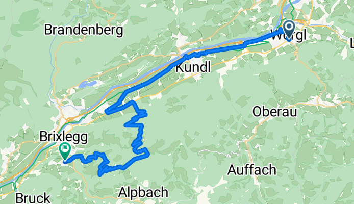
<div style="padding-top: 10px;"> Ausgehend von Wörgl (511m) rollen wir am Inntalradweg flach Richtung West
Kurz nach Mauken (521m) beginnt ein anstrengender, aber mit prächtigen Tiefblicken entschädigender, 7,5km langer Anstieg. Vorbei am abseits gelegenen Schwarzenberg (1.168m) gelangen wir schließlich zum Gasthof Holzlalm (1.452m). Von nun an geht es nur noch auf abwechslungsreicher Strecke bergab, vorbei am Scheffachberg (930m), direkt nach Reith im Alpbachtal (637m) unserem Zielort. </div>
- -:--
- Duration
- 35.3 km
- Distance
- 1,206 m
- Ascent
- 612 m
- Descent
- ---
- Avg. speed
- 1,112 m
- Avg. speed
Route quality
Waytypes & surfaces along the route
Waytypes
Track
19.6 km
(55 %)
Quiet road
9.3 km
(26 %)
Surfaces
Paved
15.2 km
(43 %)
Unpaved
15.1 km
(43 %)
Asphalt
15 km
(42 %)
Gravel
14.5 km
(41 %)
Continue with Bikemap
Use, edit, or download this cycling route
You would like to ride Kitzbüheler Alpen Rundtour Tag 1 or customize it for your own trip? Here is what you can do with this Bikemap route:
Free features
- Save this route as favorite or in collections
- Copy & plan your own version of this route
- Sync your route with Garmin or Wahoo
Premium features
Free trial for 3 days, or one-time payment. More about Bikemap Premium.
- Navigate this route on iOS & Android
- Export a GPX / KML file of this route
- Create your custom printout (try it for free)
- Download this route for offline navigation
Discover more Premium features.
Get Bikemap PremiumFrom our community
Other popular routes starting in Wörgl
 Rund um den Wilden Kaiser
- Distance
- 101.1 km
- Ascent
- 1,005 m
- Descent
- 1,023 m
- Location
- Wörgl, Tyrol, Austria
 Zauberwinkl/Häring über Kreuzweg
- Distance
- 17.1 km
- Ascent
- 643 m
- Descent
- 565 m
- Location
- Wörgl, Tyrol, Austria
 Wörgl - Hopfgarten - Kühle Luft - Möslam - Wörgl
- Distance
- 25.9 km
- Ascent
- 594 m
- Descent
- 594 m
- Location
- Wörgl, Tyrol, Austria
 Innsbrucker Straße 71, Wörgl nach Kelchsauer Straße 27, Glantersberg
- Distance
- 14.6 km
- Ascent
- 133 m
- Descent
- 6 m
- Location
- Wörgl, Tyrol, Austria
 Rundstrecke - Breitenbach über Kleinsöll-Mariastein-Niederbreitenbach-Badhäring-Wörgl
- Distance
- 32.2 km
- Ascent
- 218 m
- Descent
- 197 m
- Location
- Wörgl, Tyrol, Austria
 Rundstrecke - Breitenbach -Schönau - Kufstein - Schwoich - Wörgl
- Distance
- 47 km
- Ascent
- 352 m
- Descent
- 352 m
- Location
- Wörgl, Tyrol, Austria
 Wörgl nach Zell am See
- Distance
- 92.5 km
- Ascent
- 1,526 m
- Descent
- 1,261 m
- Location
- Wörgl, Tyrol, Austria
 Steinberg-Achensee-Inntal-Kleinsöll-Wörgl
- Distance
- 102.8 km
- Ascent
- 1,820 m
- Descent
- 1,785 m
- Location
- Wörgl, Tyrol, Austria
Open it in the app