

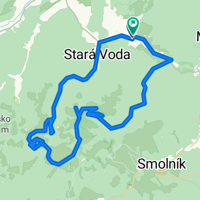
15 Via Poráčska valley, Galmus, Za Horou, Olcnava, Hornádska valley, Matejovce and back to Porač
A cycling route starting in Krompachy, Košický kraj, Slovak Republic.
Overview
About this route
The cycling route is in the part Poráč – Ploštiny – Galmus identical to the circuit no. 14. From the signpost Galmus it descends 4 kilometres following the yellow cycling trail to a small recreational centre Za Horou. After joining the Spiš arterial cycling road (the red mark CT 014), the circuit continues in the direction of Olcnava and further through the Valley of the river Hornád up its stream to the village Matejovce. From Matejovce, the circuit ascends along a blue CT trail with views of up to Poráč (behind your back).
- -:--
- Duration
- 35.3 km
- Distance
- 878 m
- Ascent
- 877 m
- Descent
- ---
- Avg. speed
- ---
- Avg. speed
Route quality
Waytypes & surfaces along the route
Waytypes
Track
30.3 km
(86 %)
Quiet road
3 km
(9 %)
Surfaces
Paved
2.2 km
(6 %)
Unpaved
19.9 km
(57 %)
Gravel
9.4 km
(27 %)
Unpaved (undefined)
8.2 km
(23 %)
Continue with Bikemap
Use, edit, or download this cycling route
You would like to ride 15 Via Poráčska valley, Galmus, Za Horou, Olcnava, Hornádska valley, Matejovce and back to Porač or customize it for your own trip? Here is what you can do with this Bikemap route:
Free features
- Save this route as favorite or in collections
- Copy & plan your own version of this route
- Sync your route with Garmin or Wahoo
Premium features
Free trial for 3 days, or one-time payment. More about Bikemap Premium.
- Navigate this route on iOS & Android
- Export a GPX / KML file of this route
- Create your custom printout (try it for free)
- Download this route for offline navigation
Discover more Premium features.
Get Bikemap PremiumFrom our community
Other popular routes starting in Krompachy
 Plejsy priehyba-Žakarovce-Mária Huta
- Distance
- 7 km
- Ascent
- 62 m
- Descent
- 606 m
- Location
- Krompachy, Košický kraj, Slovak Republic
 1deň Ostrý kameň 2deň Genier......túra
- Distance
- 16.3 km
- Ascent
- 1,029 m
- Descent
- 1,029 m
- Location
- Krompachy, Košický kraj, Slovak Republic
 Spišských 333EXTREME
- Distance
- 329.5 km
- Ascent
- 3,653 m
- Descent
- 3,653 m
- Location
- Krompachy, Košický kraj, Slovak Republic
 Around Knola
- Distance
- 84 km
- Ascent
- 1,613 m
- Descent
- 1,601 m
- Location
- Krompachy, Košický kraj, Slovak Republic
 2016_Wien_Lwiw_Tag03_202km_2.500hm
- Distance
- 201.4 km
- Ascent
- 1,439 m
- Descent
- 1,370 m
- Location
- Krompachy, Košický kraj, Slovak Republic
 Švedlár Zlatý stôl kanal Švedlár
- Distance
- 46.9 km
- Ascent
- 1,049 m
- Descent
- 1,051 m
- Location
- Krompachy, Košický kraj, Slovak Republic
 Švedlar Genier Stara Voda strará štôlna Švedlar
- Distance
- 30.2 km
- Ascent
- 828 m
- Descent
- 766 m
- Location
- Krompachy, Košický kraj, Slovak Republic
 16 Za panoramatickými výhľadmi
- Distance
- 55.2 km
- Ascent
- 868 m
- Descent
- 861 m
- Location
- Krompachy, Košický kraj, Slovak Republic
Open it in the app