

Ruhr zu Ruhr
A cycling route starting in Witten, North Rhine-Westphalia, Germany.
Overview
About this route
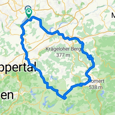
Ausgeschilderte Route "Von Ruhr zu Ruhr" etwas modifiziert. um Hauptverkehrsstraßen zu vermeiden. Start im Bommern am Ruhrtalradweg.
- -:--
- Duration
- 54 km
- Distance
- 305 m
- Ascent
- 310 m
- Descent
- ---
- Avg. speed
- ---
- Avg. speed

Route quality
Waytypes & surfaces along the route
Waytypes
Path
28.5 km
(53 %)
Quiet road
11.1 km
(20 %)
Surfaces
Paved
32.9 km
(61 %)
Unpaved
19.7 km
(36 %)
Asphalt
29.2 km
(54 %)
Gravel
16.9 km
(31 %)
Continue with Bikemap
Use, edit, or download this cycling route
You would like to ride Ruhr zu Ruhr or customize it for your own trip? Here is what you can do with this Bikemap route:
Free features
- Save this route as favorite or in collections
- Copy & plan your own version of this route
- Sync your route with Garmin or Wahoo
Premium features
Free trial for 3 days, or one-time payment. More about Bikemap Premium.
- Navigate this route on iOS & Android
- Export a GPX / KML file of this route
- Create your custom printout (try it for free)
- Download this route for offline navigation
Discover more Premium features.
Get Bikemap PremiumFrom our community
Other popular routes starting in Witten
 Lahmen Hasen V3
- Distance
- 109.4 km
- Ascent
- 842 m
- Descent
- 841 m
- Location
- Witten, North Rhine-Westphalia, Germany
 Kleine Ruhrrunde
- Distance
- 52.5 km
- Ascent
- 350 m
- Descent
- 362 m
- Location
- Witten, North Rhine-Westphalia, Germany
 ride through Witten
- Distance
- 22.8 km
- Ascent
- 465 m
- Descent
- 461 m
- Location
- Witten, North Rhine-Westphalia, Germany
 Witten-Duisburg - Ruhrtal-Radweg -
- Distance
- 82.9 km
- Ascent
- 145 m
- Descent
- 202 m
- Location
- Witten, North Rhine-Westphalia, Germany
 Von Witten bis Bochum
- Distance
- 12.5 km
- Ascent
- 118 m
- Descent
- 129 m
- Location
- Witten, North Rhine-Westphalia, Germany
 Rundkurs ums Autobahnkreuz Do-West
- Distance
- 19.9 km
- Ascent
- 93 m
- Descent
- 94 m
- Location
- Witten, North Rhine-Westphalia, Germany
 Wittentrails
- Distance
- 18.5 km
- Ascent
- 329 m
- Descent
- 329 m
- Location
- Witten, North Rhine-Westphalia, Germany
 Grosse Muttentalrunde
- Distance
- 38.9 km
- Ascent
- 515 m
- Descent
- 515 m
- Location
- Witten, North Rhine-Westphalia, Germany
Open it in the app