

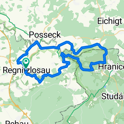
Um Regnitzlosau II (Auf Geschichtsspuren an der tschechischen Grenze)
A cycling route starting in Regnitzlosau, Bavaria, Germany.
Overview
About this route
Von der Raitschin zum verlorenen Dorf Mähring, welches zu beginn des kalten Krieges dem Grenzstreifen und Militärgebiet der deutsch-tschechoslowakischen Grenze weichen musste. Davon gibt es allerdings noch einiges zu sehen. Dann gehts weiter zum Dreiländereck Bayern-Sachsen-Böhmen und zurück zum Ausganspunkt. PS. Personalausweis nicht vergessen!!! Anschließend empfehle ich eine Einkehr im Biergarten vom Gasthof Raitschin.
- -:--
- Duration
- 35.4 km
- Distance
- 439 m
- Ascent
- 439 m
- Descent
- ---
- Avg. speed
- ---
- Avg. speed

Route quality
Waytypes & surfaces along the route
Waytypes
Track
22.9 km
(65 %)
Quiet road
7.9 km
(22 %)
Surfaces
Paved
16.4 km
(46 %)
Unpaved
13.5 km
(38 %)
Paved (undefined)
10.4 km
(29 %)
Gravel
9.9 km
(28 %)
Route highlights
Points of interest along the route
Point of interest after 6.7 km
Europabrücke
Point of interest after 8 km
Mähring Dorfplatz
Point of interest after 9.1 km
Mähring Friedhof
Point of interest after 9.7 km
ehem. Kasserne der Grenztruppen der Tschechoslowakei
Point of interest after 20.5 km
Dreiländereck
Continue with Bikemap
Use, edit, or download this cycling route
You would like to ride Um Regnitzlosau II (Auf Geschichtsspuren an der tschechischen Grenze) or customize it for your own trip? Here is what you can do with this Bikemap route:
Free features
- Save this route as favorite or in collections
- Copy & plan your own version of this route
- Sync your route with Garmin or Wahoo
Premium features
Free trial for 3 days, or one-time payment. More about Bikemap Premium.
- Navigate this route on iOS & Android
- Export a GPX / KML file of this route
- Create your custom printout (try it for free)
- Download this route for offline navigation
Discover more Premium features.
Get Bikemap PremiumFrom our community
Other popular routes starting in Regnitzlosau
 Um Regnitzlosau I
- Distance
- 27.8 km
- Ascent
- 267 m
- Descent
- 267 m
- Location
- Regnitzlosau, Bavaria, Germany
 Iron Curtain Trail (Vogtland)
- Distance
- 29.5 km
- Ascent
- 425 m
- Descent
- 422 m
- Location
- Regnitzlosau, Bavaria, Germany
 Raitschin - Faßmannsreuth
- Distance
- 12 km
- Ascent
- 76 m
- Descent
- 149 m
- Location
- Regnitzlosau, Bavaria, Germany
 GB01 DLE Ludwigsstadt
- Distance
- 91 km
- Ascent
- 939 m
- Descent
- 1,054 m
- Location
- Regnitzlosau, Bavaria, Germany
 Um Regnitzlosau III
- Distance
- 31.4 km
- Ascent
- 334 m
- Descent
- 334 m
- Location
- Regnitzlosau, Bavaria, Germany
 Grenz-Radtour bis Wittingen geplant
- Distance
- 870.1 km
- Ascent
- 2,643 m
- Descent
- 3,154 m
- Location
- Regnitzlosau, Bavaria, Germany
 2023_07 Trojmezí - Hranice pěšky
- Distance
- 7.5 km
- Ascent
- 203 m
- Descent
- 217 m
- Location
- Regnitzlosau, Bavaria, Germany
 Europa-Radweg 13 Deutschland
- Distance
- 1,507.6 km
- Ascent
- 1,769 m
- Descent
- 2,302 m
- Location
- Regnitzlosau, Bavaria, Germany
Open it in the app