
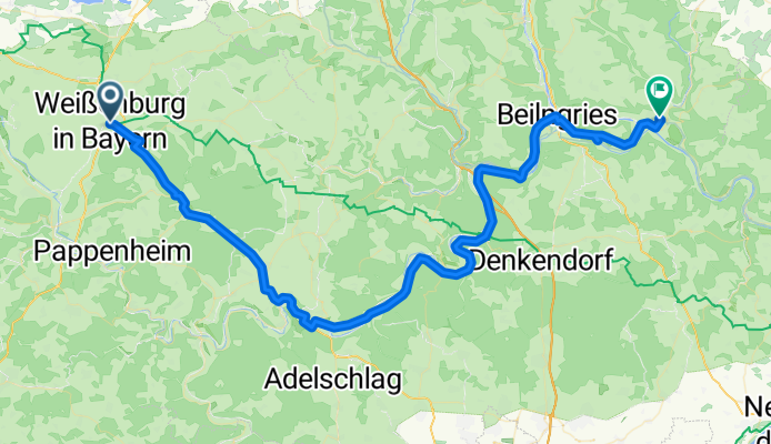
Weißenburg - Dietfurt
A cycling route starting in Weißenburg in Bayern, Bavaria, Germany.
Overview
About this route
- -:--
- Duration
- 77.8 km
- Distance
- 681 m
- Ascent
- 738 m
- Descent
- ---
- Avg. speed
- 595 m
- Avg. speed
Route quality
Waytypes & surfaces along the route
Waytypes
Busy road
50.4 km
(65 %)
Track
8.5 km
(11 %)
Surfaces
Paved
68.9 km
(88 %)
Unpaved
5.4 km
(7 %)
Asphalt
66.4 km
(85 %)
Gravel
4.3 km
(6 %)
Continue with Bikemap
Use, edit, or download this cycling route
You would like to ride Weißenburg - Dietfurt or customize it for your own trip? Here is what you can do with this Bikemap route:
Free features
- Save this route as favorite or in collections
- Copy & plan your own version of this route
- Sync your route with Garmin or Wahoo
Premium features
Free trial for 3 days, or one-time payment. More about Bikemap Premium.
- Navigate this route on iOS & Android
- Export a GPX / KML file of this route
- Create your custom printout (try it for free)
- Download this route for offline navigation
Discover more Premium features.
Get Bikemap PremiumFrom our community
Other popular routes starting in Weißenburg in Bayern
 Brombachsee
- Distance
- 13.2 km
- Ascent
- 176 m
- Descent
- 166 m
- Location
- Weißenburg in Bayern, Bavaria, Germany
 Stadtmauer Weißenburg – Kastell und Römerbad - Wettelsheim
- Distance
- 32.4 km
- Ascent
- 273 m
- Descent
- 276 m
- Location
- Weißenburg in Bayern, Bavaria, Germany
 Gunzenhausen - Altmühltal
- Distance
- 54.5 km
- Ascent
- 311 m
- Descent
- 312 m
- Location
- Weißenburg in Bayern, Bavaria, Germany
 Weissenburg - Krumbach (9.Tag Stralsund - Lindau)
- Distance
- 122.5 km
- Ascent
- 554 m
- Descent
- 499 m
- Location
- Weißenburg in Bayern, Bavaria, Germany
 Weissenburg-Wassertrüdingen-Weissenburg
- Distance
- 91.8 km
- Ascent
- 749 m
- Descent
- 765 m
- Location
- Weißenburg in Bayern, Bavaria, Germany
 Brombachsee - Ellingen
- Distance
- 51.7 km
- Ascent
- 474 m
- Descent
- 474 m
- Location
- Weißenburg in Bayern, Bavaria, Germany
 MFC 2010, Auf den Spuren der Römer
- Distance
- 125.3 km
- Ascent
- 887 m
- Descent
- 887 m
- Location
- Weißenburg in Bayern, Bavaria, Germany
 RTF Weissenburg 2010 137 km
- Distance
- 132.5 km
- Ascent
- 831 m
- Descent
- 832 m
- Location
- Weißenburg in Bayern, Bavaria, Germany
Open it in the app