

Mini Palm Canyon Epic
A cycling route starting in Cathedral City, California, United States of America.
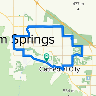
Overview
About this route
A quick sample of some of the trails that make up the Palm Canyon Epic.
- -:--
- Duration
- 23.5 km
- Distance
- 738 m
- Ascent
- 850 m
- Descent
- ---
- Avg. speed
- ---
- Avg. speed

Continue with Bikemap
Use, edit, or download this cycling route
You would like to ride Mini Palm Canyon Epic or customize it for your own trip? Here is what you can do with this Bikemap route:
Free features
- Save this route as favorite or in collections
- Copy & plan your own version of this route
- Sync your route with Garmin or Wahoo
Premium features
Free trial for 3 days, or one-time payment. More about Bikemap Premium.
- Navigate this route on iOS & Android
- Export a GPX / KML file of this route
- Create your custom printout (try it for free)
- Download this route for offline navigation
Discover more Premium features.
Get Bikemap PremiumFrom our community
Other popular routes starting in Cathedral City
 mount Jacinto climb - Indian Wells Tennis - Coachella preserve
- Distance
- 53.6 km
- Ascent
- 369 m
- Descent
- 369 m
- Location
- Cathedral City, California, United States of America
 South Winners Circle 4888, Palm Springs to Birdie Way 48818, Palm Springs
- Distance
- 16.1 km
- Ascent
- 4 m
- Descent
- 0 m
- Location
- Cathedral City, California, United States of America
 East Waverly Drive 5301, Palm Springs to East Waverly Drive 5301, Palm Springs
- Distance
- 36.8 km
- Ascent
- 134 m
- Descent
- 108 m
- Location
- Cathedral City, California, United States of America
 69787 Via del Sur, Cathedral City to 1800 S Sunrise Way, Palm Springs
- Distance
- 12 km
- Ascent
- 40 m
- Descent
- 0 m
- Location
- Cathedral City, California, United States of America
 35901 Cathedral Canyon Dr, Cathedral City to 35901 Cathedral Canyon Dr, Cathedral City
- Distance
- 25.3 km
- Ascent
- 73 m
- Descent
- 70 m
- Location
- Cathedral City, California, United States of America
 Rancho Mirage roud 3
- Distance
- 123.7 km
- Ascent
- 2,623 m
- Descent
- 2,631 m
- Location
- Cathedral City, California, United States of America
 Sunair Road 68369, Cathedral City to Sunair Road 68369, Cathedral City
- Distance
- 44.6 km
- Ascent
- 165 m
- Descent
- 156 m
- Location
- Cathedral City, California, United States of America
 Sunair Road 68369, Cathedral City to Sunair Road 68369, Cathedral City
- Distance
- 24.5 km
- Ascent
- 220 m
- Descent
- 224 m
- Location
- Cathedral City, California, United States of America
Open it in the app