
Race across the Alps Track 2014
A cycling route starting in Nauders, Tyrol, Austria.
Overview
About this route
<div class="routedescription ">
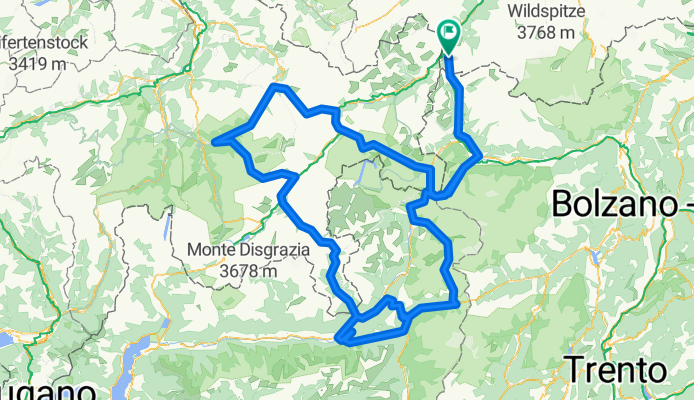
Nauders - Reschenpass - Stilfser Joch - Passo Gavia - Aprica - Passo Mortirolo - Aprica - Passo Bernina - Albulapass - Flüelapass - Ofenpass (Passo Fuorn) - Umbrailpass - Stilfser Joch - Reschenpass - Nauders </div>
- -:--
- Duration
- 517.1 km
- Distance
- 10,909 m
- Ascent
- 10,904 m
- Descent
- ---
- Avg. speed
- ---
- Avg. speed

Route quality
Waytypes & surfaces along the route
Waytypes
Busy road
290.3 km
(56 %)
Quiet road
119.1 km
(23 %)
Surfaces
Paved
437.6 km
(85 %)
Unpaved
16.9 km
(3 %)
Asphalt
433.4 km
(84 %)
Gravel
8.9 km
(2 %)
Continue with Bikemap
Use, edit, or download this cycling route
You would like to ride Race across the Alps Track 2014 or customize it for your own trip? Here is what you can do with this Bikemap route:
Free features
- Save this route as favorite or in collections
- Copy & plan your own version of this route
- Sync your route with Garmin or Wahoo
Premium features
Free trial for 3 days, or one-time payment. More about Bikemap Premium.
- Navigate this route on iOS & Android
- Export a GPX / KML file of this route
- Create your custom printout (try it for free)
- Download this route for offline navigation
Discover more Premium features.
Get Bikemap PremiumFrom our community
Other popular routes starting in Nauders
 Via Claudia - Tag 3
- Distance
- 92.7 km
- Ascent
- 656 m
- Descent
- 1,568 m
- Location
- Nauders, Tyrol, Austria
 Unbenannte Route
- Distance
- 451.8 km
- Ascent
- 6,678 m
- Descent
- 8,039 m
- Location
- Nauders, Tyrol, Austria
 Nauders Reschen Stausee und zurück
- Distance
- 29.8 km
- Ascent
- 388 m
- Descent
- 388 m
- Location
- Nauders, Tyrol, Austria
 3 Ländertour die Uina-Schlucht hoch
- Distance
- 73.6 km
- Ascent
- 1,822 m
- Descent
- 1,822 m
- Location
- Nauders, Tyrol, Austria
 Nauders erster Tag
- Distance
- 42.6 km
- Ascent
- 1,036 m
- Descent
- 1,038 m
- Location
- Nauders, Tyrol, Austria
 1. Etape_Nauders-Meran_87km
- Distance
- 86.9 km
- Ascent
- 249 m
- Descent
- 1,354 m
- Location
- Nauders, Tyrol, Austria
 Alpské průsmyky a jezera na kole
- Distance
- 487.6 km
- Ascent
- 8,111 m
- Descent
- 7,981 m
- Location
- Nauders, Tyrol, Austria
 Inntalweg (von Nauders nach Rosenheim)
- Distance
- 235 km
- Ascent
- 275 m
- Descent
- 1,190 m
- Location
- Nauders, Tyrol, Austria
Open it in the app