
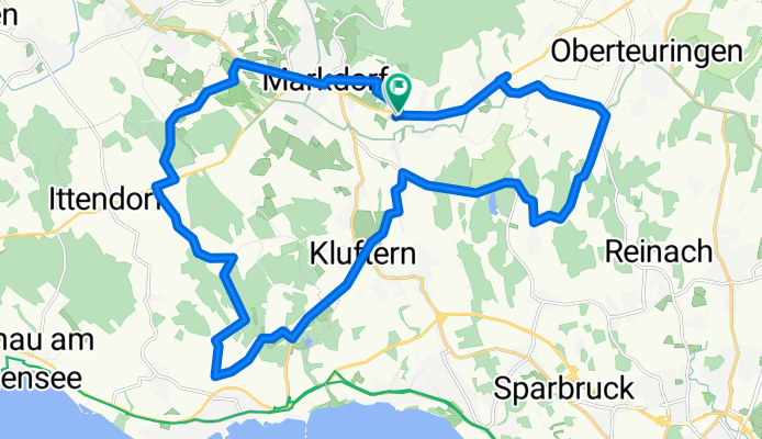
Radtour von Markdorf nach Immenstaad
A cycling route starting in Markdorf, Baden-Württemberg, Germany.
Overview
About this route
Tolle Radtour durch das Hepbacher-Leimbacher-Ried. Teilweise gibt es kleine Berge zu bezwingen.
- -:--
- Duration
- 28.3 km
- Distance
- 218 m
- Ascent
- 218 m
- Descent
- ---
- Avg. speed
- ---
- Avg. speed
Route quality
Waytypes & surfaces along the route
Waytypes
Quiet road
14.6 km
(52 %)
Busy road
4 km
(14 %)
Surfaces
Paved
27.5 km
(97 %)
Unpaved
0.7 km
(2 %)
Asphalt
27.1 km
(96 %)
Unpaved (undefined)
0.6 km
(2 %)
Continue with Bikemap
Use, edit, or download this cycling route
You would like to ride Radtour von Markdorf nach Immenstaad or customize it for your own trip? Here is what you can do with this Bikemap route:
Free features
- Save this route as favorite or in collections
- Copy & plan your own version of this route
- Sync your route with Garmin or Wahoo
Premium features
Free trial for 3 days, or one-time payment. More about Bikemap Premium.
- Navigate this route on iOS & Android
- Export a GPX / KML file of this route
- Create your custom printout (try it for free)
- Download this route for offline navigation
Discover more Premium features.
Get Bikemap PremiumFrom our community
Other popular routes starting in Markdorf
 Markdorf-Ailingen-Friedrichshafen-Kluftern-Markdorf
- Distance
- 33.5 km
- Ascent
- 269 m
- Descent
- 270 m
- Location
- Markdorf, Baden-Württemberg, Germany
 Markdorf Gehrenberg
- Distance
- 14.6 km
- Ascent
- 348 m
- Descent
- 348 m
- Location
- Markdorf, Baden-Württemberg, Germany
 Kluftern - Lindau - Bregenz - Romanshorn - Kluftern
- Distance
- 116.5 km
- Ascent
- 134 m
- Descent
- 135 m
- Location
- Markdorf, Baden-Württemberg, Germany
 MDF_MDF02_Rund-um's-Deggenhausertal_Markdorf-Horgenzell-Zußdorf-Höchsten-Oberboshasel-Heiligenberg-Altenbeuren-Untersiggingen-Markdorf
- Distance
- 70.5 km
- Ascent
- 1,003 m
- Descent
- 921 m
- Location
- Markdorf, Baden-Württemberg, Germany
 Runde durch Oberschwaben
- Distance
- 64.3 km
- Ascent
- 678 m
- Descent
- 710 m
- Location
- Markdorf, Baden-Württemberg, Germany
 Dreimal_Gehrenberg_1000HM_OBM_150315
- Distance
- 30.4 km
- Ascent
- 856 m
- Descent
- 532 m
- Location
- Markdorf, Baden-Württemberg, Germany
 MTB Route im Bodenseehinterland
- Distance
- 38.6 km
- Ascent
- 805 m
- Descent
- 805 m
- Location
- Markdorf, Baden-Württemberg, Germany
 MTB_Rund um Höchsten Gehrenberg
- Distance
- 57.4 km
- Ascent
- 912 m
- Descent
- 912 m
- Location
- Markdorf, Baden-Württemberg, Germany
Open it in the app