
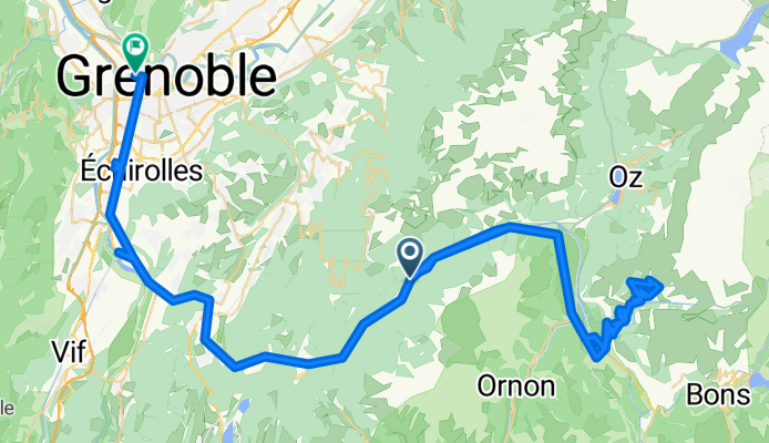
2013.07.18 Tour de France Rioupéroux - Aplpe d'Huez - Grenoble
A cycling route starting in Livet-et-Gavet, Auvergne-Rhône-Alpes, France.
Overview
About this route
Montée de l'alpe
Les coureurs passent 2 fois. Victoire d'1 français Descente avec la caravane- -:--
- Duration
- 99.2 km
- Distance
- 1,264 m
- Ascent
- 1,623 m
- Descent
- ---
- Avg. speed
- ---
- Avg. speed
Continue with Bikemap
Use, edit, or download this cycling route
You would like to ride 2013.07.18 Tour de France Rioupéroux - Aplpe d'Huez - Grenoble or customize it for your own trip? Here is what you can do with this Bikemap route:
Free features
- Save this route as favorite or in collections
- Copy & plan your own version of this route
- Sync your route with Garmin or Wahoo
Premium features
Free trial for 3 days, or one-time payment. More about Bikemap Premium.
- Navigate this route on iOS & Android
- Export a GPX / KML file of this route
- Create your custom printout (try it for free)
- Download this route for offline navigation
Discover more Premium features.
Get Bikemap PremiumFrom our community
Other popular routes starting in Livet-et-Gavet
 Rochetaillée - Galibier - Croix de fer
- Distance
- 166.5 km
- Ascent
- 3,351 m
- Descent
- 3,353 m
- Location
- Livet-et-Gavet, Auvergne-Rhône-Alpes, France
 Col de la Croix de Fer
- Distance
- 120.8 km
- Ascent
- 3,855 m
- Descent
- 3,339 m
- Location
- Livet-et-Gavet, Auvergne-Rhône-Alpes, France
 Alpes 2008 - Day 5
- Distance
- 125.9 km
- Ascent
- 3,644 m
- Descent
- 3,350 m
- Location
- Livet-et-Gavet, Auvergne-Rhône-Alpes, France
 Col de la Morte, Col de Ornon
- Distance
- 88.5 km
- Ascent
- 1,794 m
- Descent
- 1,818 m
- Location
- Livet-et-Gavet, Auvergne-Rhône-Alpes, France
 Oulles, Oz en Oisans
- Distance
- 104.6 km
- Ascent
- 2,854 m
- Descent
- 2,854 m
- Location
- Livet-et-Gavet, Auvergne-Rhône-Alpes, France
 Livet_Villard-Reculas_Alpe_Huez_descente_chute
- Distance
- 31.5 km
- Ascent
- 1,217 m
- Descent
- 494 m
- Location
- Livet-et-Gavet, Auvergne-Rhône-Alpes, France
 Col de Corbière
- Distance
- 58.2 km
- Ascent
- 1,558 m
- Descent
- 1,525 m
- Location
- Livet-et-Gavet, Auvergne-Rhône-Alpes, France
 2013.07.18 Tour de France Rioupéroux - Aplpe d'Huez - Grenoble
- Distance
- 99.2 km
- Ascent
- 1,264 m
- Descent
- 1,623 m
- Location
- Livet-et-Gavet, Auvergne-Rhône-Alpes, France
Open it in the app