

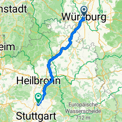
Würzburg - Lohr auf dem Main - Radweg
A cycling route starting in Wurzburg, Bavaria, Germany.
Overview
About this route
Mit Birgit zusammen radelte ich auf dem Main-Radweg. Dieser ist auf dem Teilstück bis Gemünden sehr gut und einfach zu fahren.
Dahinter sind bis Lohr kleinere Anstiege im Weg, aber gerade gut genug, daß man nicht den ganzen Tag in der topfeben herumradelt.
Die Rückfahrt fand mit dem Zug nach Würzburg statt.
- -:--
- Duration
- 62 km
- Distance
- 129 m
- Ascent
- 146 m
- Descent
- ---
- Avg. speed
- ---
- Avg. speed

Continue with Bikemap
Use, edit, or download this cycling route
You would like to ride Würzburg - Lohr auf dem Main - Radweg or customize it for your own trip? Here is what you can do with this Bikemap route:
Free features
- Save this route as favorite or in collections
- Copy & plan your own version of this route
- Sync your route with Garmin or Wahoo
Premium features
Free trial for 3 days, or one-time payment. More about Bikemap Premium.
- Navigate this route on iOS & Android
- Export a GPX / KML file of this route
- Create your custom printout (try it for free)
- Download this route for offline navigation
Discover more Premium features.
Get Bikemap PremiumFrom our community
Other popular routes starting in Wurzburg
 1-Romantische Straße, Würzburg - Füssen, Teil 1 CLONED FROM ROUTE 181277
- Distance
- 105.7 km
- Ascent
- 476 m
- Descent
- 245 m
- Location
- Wurzburg, Bavaria, Germany
 Würzburg nach Kochersteinsfeld Import aus Komoot
- Distance
- 96.8 km
- Ascent
- 1,027 m
- Descent
- 1,016 m
- Location
- Wurzburg, Bavaria, Germany
 Rückermainstraße, Würzburg to Place de la Palud, Lausanne
- Distance
- 627.9 km
- Ascent
- 6,215 m
- Descent
- 5,892 m
- Location
- Wurzburg, Bavaria, Germany
 Würzburg über Winterhausen, Albertshausen
- Distance
- 33.2 km
- Ascent
- 188 m
- Descent
- 189 m
- Location
- Wurzburg, Bavaria, Germany
 Würzburg nach Ludwigsburg Import aus Komoot
- Distance
- 151.2 km
- Ascent
- 1,200 m
- Descent
- 1,177 m
- Location
- Wurzburg, Bavaria, Germany
 Würzburg nach Rothenburg
- Distance
- 77.9 km
- Ascent
- 580 m
- Descent
- 342 m
- Location
- Wurzburg, Bavaria, Germany
 Steinbachtal-H'berg-Waldbüttelbrunn-H'berg-Steinbachtal
- Distance
- 16.9 km
- Ascent
- 239 m
- Descent
- 236 m
- Location
- Wurzburg, Bavaria, Germany
 Würzburg Kochersteinsfeld über Ochsenfurt -ausgeglichen
- Distance
- 121.1 km
- Ascent
- 1,430 m
- Descent
- 1,418 m
- Location
- Wurzburg, Bavaria, Germany
Open it in the app