
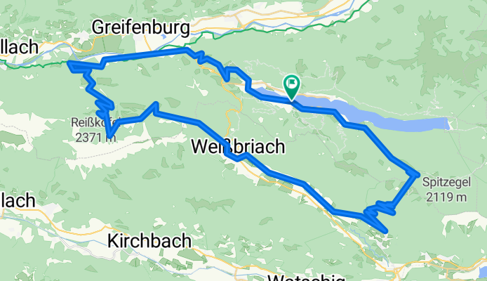
Weißensee - Ebenberg - Comptonhütte - Weißbriach - Radnig - Bodenalm - Weißensee
A cycling route starting in Steinfeld, Carinthia, Austria.
Overview
About this route
anspruchsvolle MTB-Tagestour durch die Gailtaler Alpen
Asphalt (Kreuzberg) über Tschabitscher und Tröbelsberg ausweichen; ab Bruggen Drauradweg bis Feistritz (Berg), dann Richtung Ochsenschlucht/Ebenberg, danach sehr viele Forststraßen!! Fast alle führen irgendwie zur Comptonhütte; Richtung Weißbriach gibt es auch mehrere Möglichkeiten; ab Weißbriach den Gitschtalrasweg entlang der Gössering bis Jadersdorf; dann Wanderweg (Schotterstr.) Richtung Radnig folgen kurzes Stück Single Trail zum Wasserfall; in Radnig Richtung Radniger Alm/Golz (ausgezeichnete MTB-Route) auf der Radniger Alm Wanderweg Richtung Bodenalm; steiler anspruchsvoller Single Trail mit Spitzkehren und tw. großen Steinen; vor der Bodenalm wieder Forststrasse- -:--
- Duration
- 72.9 km
- Distance
- 2,162 m
- Ascent
- 2,165 m
- Descent
- ---
- Avg. speed
- ---
- Avg. speed

Continue with Bikemap
Use, edit, or download this cycling route
You would like to ride Weißensee - Ebenberg - Comptonhütte - Weißbriach - Radnig - Bodenalm - Weißensee or customize it for your own trip? Here is what you can do with this Bikemap route:
Free features
- Save this route as favorite or in collections
- Copy & plan your own version of this route
- Sync your route with Garmin or Wahoo
Premium features
Free trial for 3 days, or one-time payment. More about Bikemap Premium.
- Navigate this route on iOS & Android
- Export a GPX / KML file of this route
- Create your custom printout (try it for free)
- Download this route for offline navigation
Discover more Premium features.
Get Bikemap PremiumFrom our community
Other popular routes starting in Steinfeld
 Große Weissenseerunde
- Distance
- 63.5 km
- Ascent
- 1,078 m
- Descent
- 1,433 m
- Location
- Steinfeld, Carinthia, Austria
 auf dem Drauradweg von Kleblach-Lind nach Dellach
- Distance
- 59 km
- Ascent
- 745 m
- Descent
- 745 m
- Location
- Steinfeld, Carinthia, Austria
 KäS3: Weissensee-Gödersdorf; 71,3km 360hm
- Distance
- 74.4 km
- Ascent
- 554 m
- Descent
- 952 m
- Location
- Steinfeld, Carinthia, Austria
 Weißensee Kohlrösselhütte Kreuzberg Hermagor
- Distance
- 46.7 km
- Ascent
- 1,084 m
- Descent
- 1,509 m
- Location
- Steinfeld, Carinthia, Austria
 Short ride from Weißensee to Techendorf
- Distance
- 5.8 km
- Ascent
- 197 m
- Descent
- 580 m
- Location
- Steinfeld, Carinthia, Austria
 von Kleblach-Lind nach Unterkolbnitz
- Distance
- 44 km
- Ascent
- 549 m
- Descent
- 549 m
- Location
- Steinfeld, Carinthia, Austria
 Weißensee
- Distance
- 16.1 km
- Ascent
- 162 m
- Descent
- 163 m
- Location
- Steinfeld, Carinthia, Austria
 R3 ab Hotel 25km 360HM Boot zurück
- Distance
- 25.8 km
- Ascent
- 422 m
- Descent
- 428 m
- Location
- Steinfeld, Carinthia, Austria
Open it in the app