

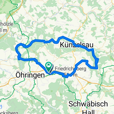
Neuenstein-Gaildorf
A cycling route starting in Neuenstein, Baden-Württemberg, Germany.
Overview
About this route
Neuenstein-Obersöllbach Oberohrn durch das Ohrntal bis Schuppach dann von Schuppach rechts nach Hegenhäule O.Z. von Geißelhardt über Gailsbach runter zur Mittelmühle dann wieder hoch nach Mainhardt von Mainhardt runter zur Rösersmühle von dort dem Rottalweg entlang bis nach Gaildorf zum Bahnhof Gaildorf-West. Von Gaildorf -West nach SHA - Hessental umsteigen Richtung Heilbronn Stationen- Schwäb. Hall-Wackershofen-Waldenburg- Neuenstein Ausstieg rechts
(cloned from route 2628995)
- -:--
- Duration
- 59.1 km
- Distance
- 399 m
- Ascent
- 348 m
- Descent
- ---
- Avg. speed
- ---
- Avg. speed

Route quality
Waytypes & surfaces along the route
Waytypes
Track
19.5 km
(33 %)
Quiet road
19.5 km
(33 %)
Surfaces
Paved
40.2 km
(68 %)
Unpaved
8.8 km
(15 %)
Asphalt
35.2 km
(60 %)
Paved (undefined)
4.9 km
(8 %)
Continue with Bikemap
Use, edit, or download this cycling route
You would like to ride Neuenstein-Gaildorf or customize it for your own trip? Here is what you can do with this Bikemap route:
Free features
- Save this route as favorite or in collections
- Copy & plan your own version of this route
- Sync your route with Garmin or Wahoo
Premium features
Free trial for 3 days, or one-time payment. More about Bikemap Premium.
- Navigate this route on iOS & Android
- Export a GPX / KML file of this route
- Create your custom printout (try it for free)
- Download this route for offline navigation
Discover more Premium features.
Get Bikemap PremiumFrom our community
Other popular routes starting in Neuenstein
 Einkauf
- Distance
- 6.3 km
- Ascent
- 62 m
- Descent
- 65 m
- Location
- Neuenstein, Baden-Württemberg, Germany
 Neuenstein zum Limesblick
- Distance
- 16.7 km
- Ascent
- 114 m
- Descent
- 110 m
- Location
- Neuenstein, Baden-Württemberg, Germany
 Neuenstein über Kupferzell - Kochertal-bis Ohrnberg
- Distance
- 79.8 km
- Ascent
- 469 m
- Descent
- 473 m
- Location
- Neuenstein, Baden-Württemberg, Germany
 Kocher-Ohrn-Eppach Radweg
- Distance
- 75 km
- Ascent
- 310 m
- Descent
- 306 m
- Location
- Neuenstein, Baden-Württemberg, Germany
 Neuenstein
- Distance
- 17.6 km
- Ascent
- 192 m
- Descent
- 192 m
- Location
- Neuenstein, Baden-Württemberg, Germany
 Zum Breitenauer See
- Distance
- 22.2 km
- Ascent
- 176 m
- Descent
- 247 m
- Location
- Neuenstein, Baden-Württemberg, Germany
 Um Neuenstein
- Distance
- 18.1 km
- Ascent
- 163 m
- Descent
- 165 m
- Location
- Neuenstein, Baden-Württemberg, Germany
 Neuenstein über Neureut Niedernhall Kochertalradweg
- Distance
- 44.1 km
- Ascent
- 396 m
- Descent
- 380 m
- Location
- Neuenstein, Baden-Württemberg, Germany
Open it in the app