
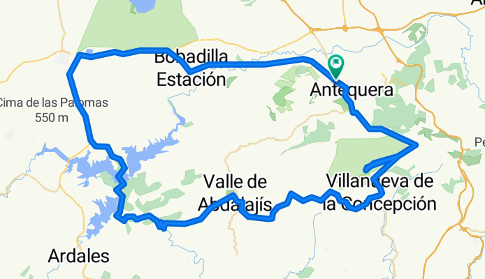
Antequera, El Chorro, Vallde de Abdalajís, La Joya, Villanueva de la C., El Torcal (cima), Antequera
A cycling route starting in Antequera, Andalusia, Spain.
Overview
About this route
Antequera, El Chorro, Vallde de Abdalajís, La Joya, Villanueva de la C., El Torcal (cima), Antequera
- -:--
- Duration
- 108.9 km
- Distance
- 1,575 m
- Ascent
- 1,573 m
- Descent
- ---
- Avg. speed
- ---
- Avg. speed
Route quality
Waytypes & surfaces along the route
Waytypes
Road
76.5 km
(70 %)
Busy road
30.2 km
(28 %)
Surfaces
Paved
73.2 km
(67 %)
Unpaved
0.6 km
(<1 %)
Asphalt
58 km
(53 %)
Paved (undefined)
14.9 km
(14 %)
Continue with Bikemap
Use, edit, or download this cycling route
You would like to ride Antequera, El Chorro, Vallde de Abdalajís, La Joya, Villanueva de la C., El Torcal (cima), Antequera or customize it for your own trip? Here is what you can do with this Bikemap route:
Free features
- Save this route as favorite or in collections
- Copy & plan your own version of this route
- Sync your route with Garmin or Wahoo
Premium features
Free trial for 3 days, or one-time payment. More about Bikemap Premium.
- Navigate this route on iOS & Android
- Export a GPX / KML file of this route
- Create your custom printout (try it for free)
- Download this route for offline navigation
Discover more Premium features.
Get Bikemap PremiumFrom our community
Other popular routes starting in Antequera
 DESAFIO TORCAL
- Distance
- 42.6 km
- Ascent
- 1,091 m
- Descent
- 1,088 m
- Location
- Antequera, Andalusia, Spain
 9ª R.N.9 km Eta Antequera - Valdepeñas de Jaén 163,7km
- Distance
- 172.4 km
- Ascent
- 1,893 m
- Descent
- 1,424 m
- Location
- Antequera, Andalusia, Spain
 Reto Piedra sobre Piedra MTB 2015
- Distance
- 60.5 km
- Ascent
- 1,384 m
- Descent
- 663 m
- Location
- Antequera, Andalusia, Spain
 Vuelta El Chorro desde Antequera
- Distance
- 111.8 km
- Ascent
- 1,269 m
- Descent
- 1,257 m
- Location
- Antequera, Andalusia, Spain
 Start md berg och sen uuuuutttföööörrr...
- Distance
- 122.2 km
- Ascent
- 1,397 m
- Descent
- 1,381 m
- Location
- Antequera, Andalusia, Spain
 Antequera-Málaga
- Distance
- 56.3 km
- Ascent
- 669 m
- Descent
- 1,175 m
- Location
- Antequera, Andalusia, Spain
 Antequera-Lucena CRI
- Distance
- 53.7 km
- Ascent
- 473 m
- Descent
- 461 m
- Location
- Antequera, Andalusia, Spain
 Antequera - Subida al Torcal - Antequera - Mollina - Humilladero - Fuente de Piedra - Sierra de Yeguas
- Distance
- 76.2 km
- Ascent
- 1,080 m
- Descent
- 1,118 m
- Location
- Antequera, Andalusia, Spain
Open it in the app