

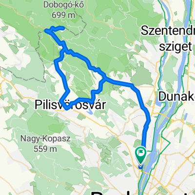
Budapest-Tata
A cycling route starting in Budapest III. kerület, Budapest főváros, Hungary.
Overview
About this route
Használható minőségű aszfaltút kicsi forgalommal, de Máriahalom és Epöl között az út minősége egy tragádia.
Országútival lassan és óvatosan, de járható.
- -:--
- Duration
- 72.9 km
- Distance
- 673 m
- Ascent
- 560 m
- Descent
- ---
- Avg. speed
- 302 m
- Avg. speed
Route quality
Waytypes & surfaces along the route
Waytypes
Busy road
55.2 km
(76 %)
Quiet road
10.3 km
(14 %)
Surfaces
Paved
39.9 km
(55 %)
Unpaved
1.5 km
(2 %)
Asphalt
38.6 km
(53 %)
Paving stones
1.4 km
(2 %)
Continue with Bikemap
Use, edit, or download this cycling route
You would like to ride Budapest-Tata or customize it for your own trip? Here is what you can do with this Bikemap route:
Free features
- Save this route as favorite or in collections
- Copy & plan your own version of this route
- Sync your route with Garmin or Wahoo
Premium features
Free trial for 3 days, or one-time payment. More about Bikemap Premium.
- Navigate this route on iOS & Android
- Export a GPX / KML file of this route
- Create your custom printout (try it for free)
- Download this route for offline navigation
Discover more Premium features.
Get Bikemap PremiumFrom our community
Other popular routes starting in Budapest III. kerület
 Pilis Classic edzőkör
- Distance
- 96.4 km
- Ascent
- 940 m
- Descent
- 942 m
- Location
- Budapest III. kerület, Budapest főváros, Hungary
 Coffee Ride - Csobánka Szántó Dobogókő
- Distance
- 74.3 km
- Ascent
- 716 m
- Descent
- 720 m
- Location
- Budapest III. kerület, Budapest főváros, Hungary
 CR - Paprét - Pilisszentkereszt - Dobogókő
- Distance
- 83.8 km
- Ascent
- 914 m
- Descent
- 913 m
- Location
- Budapest III. kerület, Budapest főváros, Hungary
 CR - Skanzen kör
- Distance
- 44.8 km
- Ascent
- 169 m
- Descent
- 166 m
- Location
- Budapest III. kerület, Budapest főváros, Hungary
 HHH gyors
- Distance
- 16 km
- Ascent
- 477 m
- Descent
- 477 m
- Location
- Budapest III. kerület, Budapest főváros, Hungary
 Coffee Ride - Paprét + Szentkereszt
- Distance
- 73.1 km
- Ascent
- 730 m
- Descent
- 728 m
- Location
- Budapest III. kerület, Budapest főváros, Hungary
 Vihar utca, Budapest to Őrlő utca, Budapest
- Distance
- 13 km
- Ascent
- 117 m
- Descent
- 119 m
- Location
- Budapest III. kerület, Budapest főváros, Hungary
 Alternatív rövid könnyű útvonal
- Distance
- 34.1 km
- Ascent
- 211 m
- Descent
- 207 m
- Location
- Budapest III. kerület, Budapest főváros, Hungary
Open it in the app