

Reher - Schenefeld
A cycling route starting in Reher, Schleswig-Holstein, Germany.
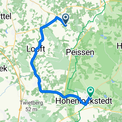
Overview
About this route
Ab Gokels aufn Radweg nach Schenefeld. (bergab)
- -:--
- Duration
- 17.2 km
- Distance
- 56 m
- Ascent
- 59 m
- Descent
- ---
- Avg. speed
- 51 m
- Avg. speed
Route quality
Waytypes & surfaces along the route
Waytypes
Busy road
9.5 km
(55 %)
Path
3.3 km
(19 %)
Surfaces
Paved
16.3 km
(95 %)
Asphalt
14.3 km
(83 %)
Paving stones
1.8 km
(11 %)
Continue with Bikemap
Use, edit, or download this cycling route
You would like to ride Reher - Schenefeld or customize it for your own trip? Here is what you can do with this Bikemap route:
Free features
- Save this route as favorite or in collections
- Copy & plan your own version of this route
- Sync your route with Garmin or Wahoo
Premium features
Free trial for 3 days, or one-time payment. More about Bikemap Premium.
- Navigate this route on iOS & Android
- Export a GPX / KML file of this route
- Create your custom printout (try it for free)
- Download this route for offline navigation
Discover more Premium features.
Get Bikemap PremiumFrom our community
Other popular routes starting in Reher
 Reher - Schenefeld
- Distance
- 17.2 km
- Ascent
- 56 m
- Descent
- 59 m
- Location
- Reher, Schleswig-Holstein, Germany
 Vierthstraße 7, Reher nach Seeuferweg 8A, Damp
- Distance
- 83.6 km
- Ascent
- 290 m
- Descent
- 309 m
- Location
- Reher, Schleswig-Holstein, Germany
 Vierthstraße 12, Reher nach Vierthstraße 12, Reher
- Distance
- 39.9 km
- Ascent
- 72 m
- Descent
- 75 m
- Location
- Reher, Schleswig-Holstein, Germany
 Reher - Holo
- Distance
- 21.1 km
- Ascent
- 44 m
- Descent
- 60 m
- Location
- Reher, Schleswig-Holstein, Germany
 1
1- Distance
- 36.5 km
- Ascent
- 191 m
- Descent
- 204 m
- Location
- Reher, Schleswig-Holstein, Germany
 NOKNOK
- Distance
- 42.2 km
- Ascent
- 109 m
- Descent
- 109 m
- Location
- Reher, Schleswig-Holstein, Germany
 Reher - Wilster (Kanal)
- Distance
- 48.7 km
- Ascent
- 94 m
- Descent
- 125 m
- Location
- Reher, Schleswig-Holstein, Germany
 Vierthstraße 44, Reher nach Eichenweg 4, Hohenaspe
- Distance
- 13.2 km
- Ascent
- 29 m
- Descent
- 74 m
- Location
- Reher, Schleswig-Holstein, Germany
Open it in the app