
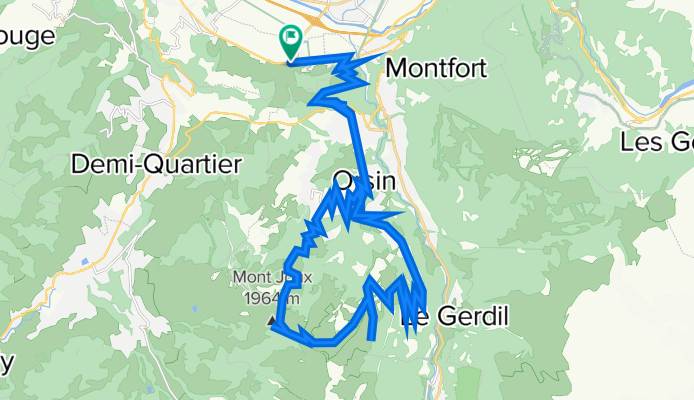
Col de Christ
A cycling route starting in Passy, Auvergne-Rhône-Alpes, France.
Overview
About this route
Mountain biking to the top of the Megève ski slopes.
Blog Post here- -:--
- Duration
- 40.5 km
- Distance
- 1,430 m
- Ascent
- 1,429 m
- Descent
- ---
- Avg. speed
- ---
- Avg. speed

Route highlights
Points of interest along the route
Point of interest after 16.6 km
Col de Christ
Point of interest after 17.4 km
Mont Joux
Continue with Bikemap
Use, edit, or download this cycling route
You would like to ride Col de Christ or customize it for your own trip? Here is what you can do with this Bikemap route:
Free features
- Save this route as favorite or in collections
- Copy & plan your own version of this route
- Sync your route with Garmin or Wahoo
Premium features
Free trial for 3 days, or one-time payment. More about Bikemap Premium.
- Navigate this route on iOS & Android
- Export a GPX / KML file of this route
- Create your custom printout (try it for free)
- Download this route for offline navigation
Discover more Premium features.
Get Bikemap PremiumFrom our community
Other popular routes starting in Passy
 balade tour des lacs
- Distance
- 8 km
- Ascent
- 37 m
- Descent
- 37 m
- Location
- Passy, Auvergne-Rhône-Alpes, France
 Passy - Colombière
- Distance
- 96.1 km
- Ascent
- 1,990 m
- Descent
- 1,877 m
- Location
- Passy, Auvergne-Rhône-Alpes, France
 De Avenue Léman Mont-Blanc 170, Passy à Hameau des Fiz 140, Passy
- Distance
- 54.2 km
- Ascent
- 519 m
- Descent
- 522 m
- Location
- Passy, Auvergne-Rhône-Alpes, France
 De Chemin des Parchets 324, Passy à Chemin des Parchets 350, Passy
- Distance
- 0.1 km
- Ascent
- 0 m
- Descent
- 0 m
- Location
- Passy, Auvergne-Rhône-Alpes, France
 Passy 2012
- Distance
- 103.6 km
- Ascent
- 1,992 m
- Descent
- 1,987 m
- Location
- Passy, Auvergne-Rhône-Alpes, France
 Passy - Reserve de Passy
- Distance
- 19.5 km
- Ascent
- 1,399 m
- Descent
- 111 m
- Location
- Passy, Auvergne-Rhône-Alpes, France
 passy - combloux
- Distance
- 22.4 km
- Ascent
- 667 m
- Descent
- 273 m
- Location
- Passy, Auvergne-Rhône-Alpes, France
 Chamonix - Chambesy
- Distance
- 76.7 km
- Ascent
- 374 m
- Descent
- 1,179 m
- Location
- Passy, Auvergne-Rhône-Alpes, France
Open it in the app