

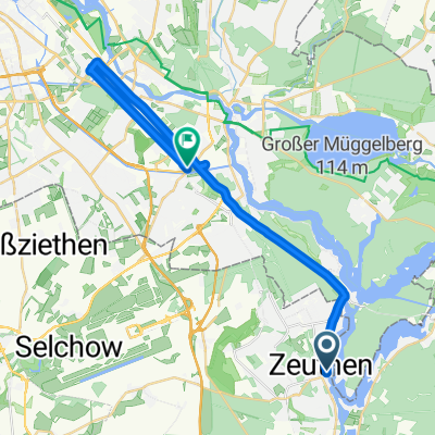
Schulzendorf - Schloß Köpenick
A cycling route starting in Zeuthen, Brandenburg, Germany.
Overview
About this route
Route zum Schloß Köpenick
(cloned from route 2678648)
- -:--
- Duration
- 10.3 km
- Distance
- 32 m
- Ascent
- 31 m
- Descent
- ---
- Avg. speed
- ---
- Avg. speed
Route quality
Waytypes & surfaces along the route
Waytypes
Quiet road
3.4 km
(33 %)
Pedestrian area
3.1 km
(30 %)
Surfaces
Paved
10.2 km
(99 %)
Asphalt
5.7 km
(55 %)
Paving stones
4.5 km
(44 %)
Undefined
0.1 km
(1 %)
Continue with Bikemap
Use, edit, or download this cycling route
You would like to ride Schulzendorf - Schloß Köpenick or customize it for your own trip? Here is what you can do with this Bikemap route:
Free features
- Save this route as favorite or in collections
- Copy & plan your own version of this route
- Sync your route with Garmin or Wahoo
Premium features
Free trial for 3 days, or one-time payment. More about Bikemap Premium.
- Navigate this route on iOS & Android
- Export a GPX / KML file of this route
- Create your custom printout (try it for free)
- Download this route for offline navigation
Discover more Premium features.
Get Bikemap PremiumFrom our community
Other popular routes starting in Zeuthen
 Tagestour
- Distance
- 22.5 km
- Ascent
- 37 m
- Descent
- 40 m
- Location
- Zeuthen, Brandenburg, Germany
 Rund um Berlin
- Distance
- 179.5 km
- Ascent
- 497 m
- Descent
- 497 m
- Location
- Zeuthen, Brandenburg, Germany
 Spreeradweg
- Distance
- 144.7 km
- Ascent
- 156 m
- Descent
- 156 m
- Location
- Zeuthen, Brandenburg, Germany
 ride from Zeuthen to Berlin
- Distance
- 25.6 km
- Ascent
- 20 m
- Descent
- 23 m
- Location
- Zeuthen, Brandenburg, Germany
 Zeuthen -> Storkow -> Zeuthen
- Distance
- 76.3 km
- Ascent
- 133 m
- Descent
- 130 m
- Location
- Zeuthen, Brandenburg, Germany
 Steady ride in
- Distance
- 10.2 km
- Ascent
- 66 m
- Descent
- 64 m
- Location
- Zeuthen, Brandenburg, Germany
 Märkische Schweiz
- Distance
- 147.2 km
- Ascent
- 591 m
- Descent
- 591 m
- Location
- Zeuthen, Brandenburg, Germany
 Route West Eichwalde/Tempelhof
- Distance
- 36.5 km
- Ascent
- 83 m
- Descent
- 72 m
- Location
- Zeuthen, Brandenburg, Germany
Open it in the app