

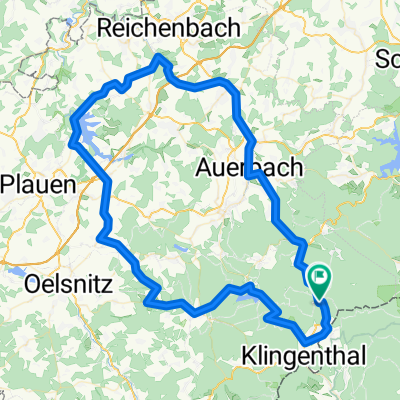
Vogtland - Erzgebirge - Tschechien
A cycling route starting in Tannenbergsthal, Saxony, Germany.
Overview
About this route
- -:--
- Duration
- 120.8 km
- Distance
- 1,792 m
- Ascent
- 1,806 m
- Descent
- ---
- Avg. speed
- ---
- Avg. speed

Continue with Bikemap
Use, edit, or download this cycling route
You would like to ride Vogtland - Erzgebirge - Tschechien or customize it for your own trip? Here is what you can do with this Bikemap route:
Free features
- Save this route as favorite or in collections
- Copy & plan your own version of this route
- Sync your route with Garmin or Wahoo
Premium features
Free trial for 3 days, or one-time payment. More about Bikemap Premium.
- Navigate this route on iOS & Android
- Export a GPX / KML file of this route
- Create your custom printout (try it for free)
- Download this route for offline navigation
Discover more Premium features.
Get Bikemap PremiumFrom our community
Other popular routes starting in Tannenbergsthal
 Mühlleithen-Bublava-Brunndöbra-Mühlleithen
- Distance
- 17.8 km
- Ascent
- 427 m
- Descent
- 427 m
- Location
- Tannenbergsthal, Saxony, Germany
 TBT - Klingenthal - TBT
- Distance
- 25.2 km
- Ascent
- 500 m
- Descent
- 500 m
- Location
- Tannenbergsthal, Saxony, Germany
 Höhenmeter sammeln
- Distance
- 39.2 km
- Ascent
- 998 m
- Descent
- 963 m
- Location
- Tannenbergsthal, Saxony, Germany
 ZP KH Mühlleiten - PERNINK
- Distance
- 27.1 km
- Ascent
- 393 m
- Descent
- 419 m
- Location
- Tannenbergsthal, Saxony, Germany
 Mühlleithen-Zwenckau V3
- Distance
- 116 km
- Ascent
- 177 m
- Descent
- 905 m
- Location
- Tannenbergsthal, Saxony, Germany
 Kammtour Erzgebirge Auf dem höchsten Weg durch Sachsen und Böhmen - Kammtour Erzgebirge Auf dem höchsten Weg durch Sachsen und Böhmen
- Distance
- 233.8 km
- Ascent
- 2,873 m
- Descent
- 3,132 m
- Location
- Tannenbergsthal, Saxony, Germany
 Zusatz Männerstagsride zum Schneckenstein (Tannenbergsthal)
- Distance
- 9 km
- Ascent
- 231 m
- Descent
- 200 m
- Location
- Tannenbergsthal, Saxony, Germany
 Vogtland -2-
- Distance
- 93.5 km
- Ascent
- 1,141 m
- Descent
- 1,149 m
- Location
- Tannenbergsthal, Saxony, Germany
Open it in the app