

Le TOIT DU VAR - Mont Lachens
A cycling route starting in Saint-Raphaël, Provence-Alpes-Côte d'Azur Region, France.
Overview
About this route
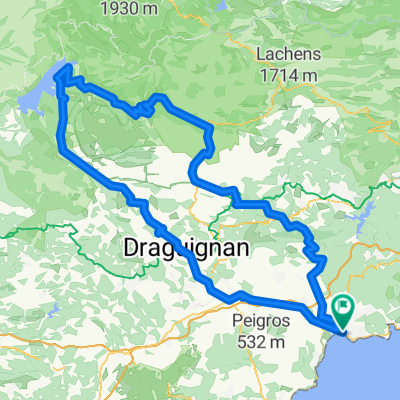
<div> Niveau NOIR, 160km, 7 heures </div> <div> </div> <div> À partir de Saint-Raphaël, prendre la direction Fréjus, puis Bagnols-en-Forêt D4, dans le village de Saint-Paul-en-Forêt prendre à gauche la D55, puis la D53 jusqu’à Brovès en Seillans, puis Seillans le col St Arnoux et Bargemon, dans le village prendre la D25 et gravir le col du Belhomme, traverser la Bastide jusqu’au col de Clavel et attaquer l’ascension du Lachens, point culminant du département 1715m. Faire demi tour jusqu’à la D44 direction Castellane, prendre à droite jusqu’à Villaute, puis la route Napoléon jusqu’au col de Val Ferrière, bifurquer à droite en direction de Mons, emprunter la D563 jusqu’à Fayence et suivre la direction Fréjus puis Saint-Raphaël.</div>
- -:--
- Duration
- 162.3 km
- Distance
- 2,177 m
- Ascent
- 2,177 m
- Descent
- ---
- Avg. speed
- ---
- Avg. speed

Route quality
Waytypes & surfaces along the route
Waytypes
Busy road
120.5 km
(74 %)
Quiet road
16.3 km
(10 %)
Surfaces
Paved
108.9 km
(67 %)
Unpaved
1 km
(<1 %)
Asphalt
108.9 km
(67 %)
Ground
0.5 km
(<1 %)
Continue with Bikemap
Use, edit, or download this cycling route
You would like to ride Le TOIT DU VAR - Mont Lachens or customize it for your own trip? Here is what you can do with this Bikemap route:
Free features
- Save this route as favorite or in collections
- Copy & plan your own version of this route
- Sync your route with Garmin or Wahoo
Premium features
Free trial for 3 days, or one-time payment. More about Bikemap Premium.
- Navigate this route on iOS & Android
- Export a GPX / KML file of this route
- Create your custom printout (try it for free)
- Download this route for offline navigation
Discover more Premium features.
Get Bikemap PremiumFrom our community
Other popular routes starting in Saint-Raphaël
 St. Raphael - Lac. St. Chroix
- Distance
- 194.3 km
- Ascent
- 2,128 m
- Descent
- 2,132 m
- Location
- Saint-Raphaël, Provence-Alpes-Côte d'Azur Region, France
 Esterel2
- Distance
- 35.8 km
- Ascent
- 550 m
- Descent
- 550 m
- Location
- Saint-Raphaël, Provence-Alpes-Côte d'Azur Region, France
 DE LA MER AUX PREMIERS CONTREFORTS…
- Distance
- 69.1 km
- Ascent
- 486 m
- Descent
- 486 m
- Location
- Saint-Raphaël, Provence-Alpes-Côte d'Azur Region, France
 taka góra we Francji
- Distance
- 2.8 km
- Ascent
- 115 m
- Descent
- 113 m
- Location
- Saint-Raphaël, Provence-Alpes-Côte d'Azur Region, France
 Tour du Mont Vinaigre
- Distance
- 17.4 km
- Ascent
- 436 m
- Descent
- 78 m
- Location
- Saint-Raphaël, Provence-Alpes-Côte d'Azur Region, France
 L'Esterel loop
- Distance
- 72 km
- Ascent
- 1,861 m
- Descent
- 1,824 m
- Location
- Saint-Raphaël, Provence-Alpes-Côte d'Azur Region, France
 Esterelleküste und -berge
- Distance
- 64 km
- Ascent
- 584 m
- Descent
- 590 m
- Location
- Saint-Raphaël, Provence-Alpes-Côte d'Azur Region, France
 Von Boulouris über Tanneron über die Corniche zurück
- Distance
- 84.8 km
- Ascent
- 2,479 m
- Descent
- 2,466 m
- Location
- Saint-Raphaël, Provence-Alpes-Côte d'Azur Region, France
Open it in the app