

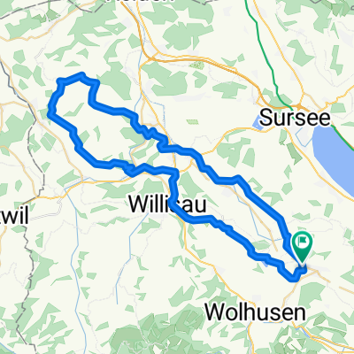
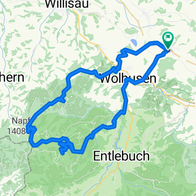
Finsterwald - Heiligkreuz First - Doppleschwand
A cycling route starting in Ruswil, Canton of Lucerne, Switzerland.
Overview
About this route
Ruswil - Wolhusen - Finsterwald - Heiligkreuz - Doppleschwand - Wolhusen - Buholz - Ruswil
- -:--
- Duration
- 66 km
- Distance
- 1,304 m
- Ascent
- 1,304 m
- Descent
- ---
- Avg. speed
- ---
- Avg. speed

Route quality
Waytypes & surfaces along the route
Waytypes
Quiet road
21.8 km
(33 %)
Track
21.3 km
(32 %)
Surfaces
Paved
27.2 km
(41 %)
Unpaved
9 km
(14 %)
Asphalt
19.2 km
(29 %)
Gravel
7.8 km
(12 %)
Continue with Bikemap
Use, edit, or download this cycling route
You would like to ride Finsterwald - Heiligkreuz First - Doppleschwand or customize it for your own trip? Here is what you can do with this Bikemap route:
Free features
- Save this route as favorite or in collections
- Copy & plan your own version of this route
- Sync your route with Garmin or Wahoo
Premium features
Free trial for 3 days, or one-time payment. More about Bikemap Premium.
- Navigate this route on iOS & Android
- Export a GPX / KML file of this route
- Create your custom printout (try it for free)
- Download this route for offline navigation
Discover more Premium features.
Get Bikemap PremiumFrom our community
Other popular routes starting in Ruswil
 Bodenberg/Schötz
- Distance
- 54.4 km
- Ascent
- 437 m
- Descent
- 432 m
- Location
- Ruswil, Canton of Lucerne, Switzerland
 Napf by bike
- Distance
- 62.2 km
- Ascent
- 1,481 m
- Descent
- 1,465 m
- Location
- Ruswil, Canton of Lucerne, Switzerland
 Ruswil - Tal - Steinhuserberg - Schübelberg
- Distance
- 24.5 km
- Ascent
- 572 m
- Descent
- 572 m
- Location
- Ruswil, Canton of Lucerne, Switzerland
 Willisau Abendrunde
- Distance
- 34.9 km
- Ascent
- 377 m
- Descent
- 433 m
- Location
- Ruswil, Canton of Lucerne, Switzerland
 Finsterwald - Heiligkreuz First - Doppleschwand
- Distance
- 66 km
- Ascent
- 1,304 m
- Descent
- 1,304 m
- Location
- Ruswil, Canton of Lucerne, Switzerland
 Ruswil Panoramatour
- Distance
- 20 km
- Ascent
- 326 m
- Descent
- 323 m
- Location
- Ruswil, Canton of Lucerne, Switzerland
 Stöckli Napf-Bikemarathon
- Distance
- 54.4 km
- Ascent
- 1,143 m
- Descent
- 1,143 m
- Location
- Ruswil, Canton of Lucerne, Switzerland
 Ruswil - Schwesteregg - Stächelegg - Geiss
- Distance
- 56.4 km
- Ascent
- 1,168 m
- Descent
- 1,168 m
- Location
- Ruswil, Canton of Lucerne, Switzerland
Open it in the app