

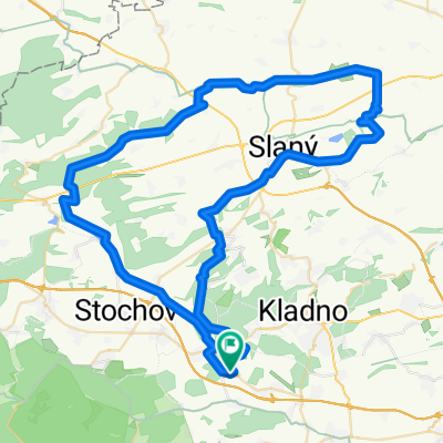
Okruh Doksy-Unhost-Markuv mlyn-Horni Bezdekov-Doksy
A cycling route starting in Doksy, Central Bohemia, Czechia.
Overview
About this route
Trasa místy technicky náročnější, úzká klikatá cesta, výmoly, kořeny, kameny apod. Rozhodně to chce MTB, i když na trekovém kole by to asi šlo taky.
- -:--
- Duration
- 30 km
- Distance
- 267 m
- Ascent
- 264 m
- Descent
- ---
- Avg. speed
- ---
- Avg. speed
Route quality
Waytypes & surfaces along the route
Waytypes
Track
10.6 km
(35 %)
Path
7.8 km
(26 %)
Surfaces
Paved
3 km
(10 %)
Unpaved
8.3 km
(28 %)
Gravel
4.4 km
(15 %)
Loose gravel
2.2 km
(7 %)
Continue with Bikemap
Use, edit, or download this cycling route
You would like to ride Okruh Doksy-Unhost-Markuv mlyn-Horni Bezdekov-Doksy or customize it for your own trip? Here is what you can do with this Bikemap route:
Free features
- Save this route as favorite or in collections
- Copy & plan your own version of this route
- Sync your route with Garmin or Wahoo
Premium features
Free trial for 3 days, or one-time payment. More about Bikemap Premium.
- Navigate this route on iOS & Android
- Export a GPX / KML file of this route
- Create your custom printout (try it for free)
- Download this route for offline navigation
Discover more Premium features.
Get Bikemap PremiumFrom our community
Other popular routes starting in Doksy
 Vraní skála
- Distance
- 82.6 km
- Ascent
- 971 m
- Descent
- 975 m
- Location
- Doksy, Central Bohemia, Czechia
 Rozhledna Pavlíkov
- Distance
- 79.9 km
- Ascent
- 751 m
- Descent
- 754 m
- Location
- Doksy, Central Bohemia, Czechia
 Rozhledna Máminka
- Distance
- 80.6 km
- Ascent
- 1,071 m
- Descent
- 1,071 m
- Location
- Doksy, Central Bohemia, Czechia
 Okruh Doksy-Unhost-Markuv mlyn-Horni Bezdekov-Doksy
- Distance
- 30 km
- Ascent
- 267 m
- Descent
- 264 m
- Location
- Doksy, Central Bohemia, Czechia
 Vyhlídka Pěnčina
- Distance
- 60.7 km
- Ascent
- 570 m
- Descent
- 570 m
- Location
- Doksy, Central Bohemia, Czechia
 Panenský Týnec - Peruc - Klobuky aneb cesta za Lemrouchem
- Distance
- 80.9 km
- Ascent
- 609 m
- Descent
- 599 m
- Location
- Doksy, Central Bohemia, Czechia
 Loušťín - Rakovnický potok - Klíčava
- Distance
- 77.2 km
- Ascent
- 678 m
- Descent
- 678 m
- Location
- Doksy, Central Bohemia, Czechia
 Prozkoumávání Slánska
- Distance
- 70.1 km
- Ascent
- 431 m
- Descent
- 431 m
- Location
- Doksy, Central Bohemia, Czechia
Open it in the app