
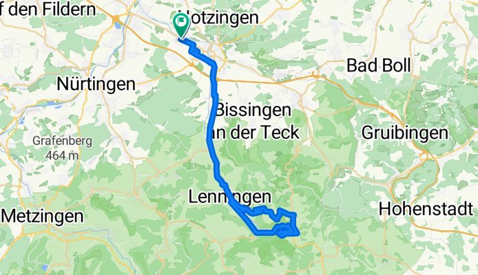
Ötlingen-Lenningen-Schopfloch
A cycling route starting in Kirchheim unter Teck, Baden-Württemberg, Germany.
Overview
About this route
- -:--
- Duration
- 47.1 km
- Distance
- 886 m
- Ascent
- 834 m
- Descent
- ---
- Avg. speed
- 764 m
- Avg. speed
Route quality
Waytypes & surfaces along the route
Waytypes
Busy road
21.6 km
(46 %)
Road
11.4 km
(24 %)
Surfaces
Paved
44.2 km
(94 %)
Unpaved
0.8 km
(2 %)
Asphalt
43.6 km
(92 %)
Ground
0.8 km
(2 %)
Continue with Bikemap
Use, edit, or download this cycling route
You would like to ride Ötlingen-Lenningen-Schopfloch or customize it for your own trip? Here is what you can do with this Bikemap route:
Free features
- Save this route as favorite or in collections
- Copy & plan your own version of this route
- Sync your route with Garmin or Wahoo
Premium features
Free trial for 3 days, or one-time payment. More about Bikemap Premium.
- Navigate this route on iOS & Android
- Export a GPX / KML file of this route
- Create your custom printout (try it for free)
- Download this route for offline navigation
Discover more Premium features.
Get Bikemap PremiumFrom our community
Other popular routes starting in Kirchheim unter Teck
 Alb - mal nicht extrem
- Distance
- 63.1 km
- Ascent
- 1,013 m
- Descent
- 1,019 m
- Location
- Kirchheim unter Teck, Baden-Württemberg, Germany
 Albtraufmarathon 2009 Mitteldistanz CLONED FROM ROUTE 314364
- Distance
- 61.5 km
- Ascent
- 878 m
- Descent
- 876 m
- Location
- Kirchheim unter Teck, Baden-Württemberg, Germany
 Maientour
- Distance
- 24.4 km
- Ascent
- 278 m
- Descent
- 277 m
- Location
- Kirchheim unter Teck, Baden-Württemberg, Germany
 Kirchheim/Teck - Beuren - Nürtingen- Wendlingen- Kirchheim/Teck
- Distance
- 35.4 km
- Ascent
- 276 m
- Descent
- 226 m
- Location
- Kirchheim unter Teck, Baden-Württemberg, Germany
 Kirchheim unter Teck, Donnstetten, Wiesensteig, Ochsenwang, Kirchheim
- Distance
- 67.7 km
- Ascent
- 951 m
- Descent
- 950 m
- Location
- Kirchheim unter Teck, Baden-Württemberg, Germany
 006_Kirchheim-Teck-Ulm
- Distance
- 77.4 km
- Ascent
- 783 m
- Descent
- 585 m
- Location
- Kirchheim unter Teck, Baden-Württemberg, Germany
 Albtraufmarathon 2009 Mitteldistanz
- Distance
- 61.4 km
- Ascent
- 1,459 m
- Descent
- 1,410 m
- Location
- Kirchheim unter Teck, Baden-Württemberg, Germany
 Kirchheim-Aichelberg-Neidlingen-Nabern
- Distance
- 29.4 km
- Ascent
- 272 m
- Descent
- 213 m
- Location
- Kirchheim unter Teck, Baden-Württemberg, Germany
Open it in the app