

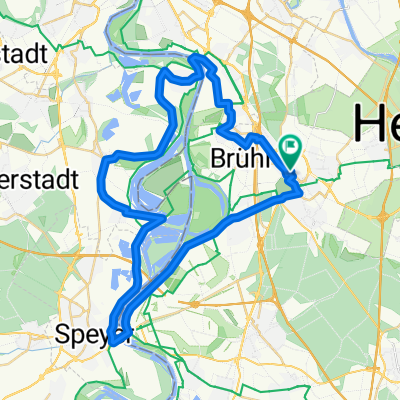
Schifferstadt, 9. August
A cycling route starting in Schwetzingen, Baden-Württemberg, Germany.
Overview
About this route
fobaar
- -:--
- Duration
- 55.6 km
- Distance
- 62 m
- Ascent
- 63 m
- Descent
- ---
- Avg. speed
- ---
- Avg. speed
Route quality
Waytypes & surfaces along the route
Waytypes
Track
16.3 km
(29 %)
Path
14.7 km
(27 %)
Surfaces
Paved
50.9 km
(91 %)
Unpaved
2.9 km
(5 %)
Asphalt
41.3 km
(74 %)
Paving stones
7.3 km
(13 %)
Continue with Bikemap
Use, edit, or download this cycling route
You would like to ride Schifferstadt, 9. August or customize it for your own trip? Here is what you can do with this Bikemap route:
Free features
- Save this route as favorite or in collections
- Copy & plan your own version of this route
- Sync your route with Garmin or Wahoo
Premium features
Free trial for 3 days, or one-time payment. More about Bikemap Premium.
- Navigate this route on iOS & Android
- Export a GPX / KML file of this route
- Create your custom printout (try it for free)
- Download this route for offline navigation
Discover more Premium features.
Get Bikemap PremiumFrom our community
Other popular routes starting in Schwetzingen
 kleine Altriprunde
- Distance
- 48.3 km
- Ascent
- 63 m
- Descent
- 68 m
- Location
- Schwetzingen, Baden-Württemberg, Germany
 RTF Odenwaldtour
- Distance
- 80.7 km
- Ascent
- 905 m
- Descent
- 904 m
- Location
- Schwetzingen, Baden-Württemberg, Germany
 Ahnenroute 495km - Tag 7 - von Oftersheim nach Weiler
- Distance
- 74.5 km
- Ascent
- 322 m
- Descent
- 194 m
- Location
- Schwetzingen, Baden-Württemberg, Germany
 Short bike tour through Schwetzingen
- Distance
- 0 km
- Ascent
- 0 m
- Descent
- 0 m
- Location
- Schwetzingen, Baden-Württemberg, Germany
 Durchs Feld
- Distance
- 23.6 km
- Ascent
- 64 m
- Descent
- 64 m
- Location
- Schwetzingen, Baden-Württemberg, Germany
 Schwetzinge - Leimen- Königstuhl- Bierhelderhof - Schwetzingen
- Distance
- 52 km
- Ascent
- 504 m
- Descent
- 507 m
- Location
- Schwetzingen, Baden-Württemberg, Germany
 RTF Rhein-Neckar-Odenwald
- Distance
- 79.7 km
- Ascent
- 298 m
- Descent
- 299 m
- Location
- Schwetzingen, Baden-Württemberg, Germany
 Schwetzingen - Walldorf - Rettigheim: Waldroute
- Distance
- 23.2 km
- Ascent
- 78 m
- Descent
- 27 m
- Location
- Schwetzingen, Baden-Württemberg, Germany
Open it in the app