

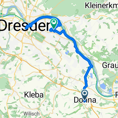
Vom Müglitztal auf den Erzgebirgskamm
A cycling route starting in Dohna, Saxony, Germany.
Overview
About this route
Langsam ansteigend bis Geising.Ab Geising etwas steiler.
- -:--
- Duration
- 35.8 km
- Distance
- 898 m
- Ascent
- 194 m
- Descent
- ---
- Avg. speed
- ---
- Avg. speed
Route quality
Waytypes & surfaces along the route
Waytypes
Busy road
27.7 km
(77 %)
Road
5 km
(14 %)
Surfaces
Paved
33.1 km
(92 %)
Unpaved
0.1 km
(<1 %)
Asphalt
33.1 km
(92 %)
Unpaved (undefined)
0.1 km
(<1 %)
Continue with Bikemap
Use, edit, or download this cycling route
You would like to ride Vom Müglitztal auf den Erzgebirgskamm or customize it for your own trip? Here is what you can do with this Bikemap route:
Free features
- Save this route as favorite or in collections
- Copy & plan your own version of this route
- Sync your route with Garmin or Wahoo
Premium features
Free trial for 3 days, or one-time payment. More about Bikemap Premium.
- Navigate this route on iOS & Android
- Export a GPX / KML file of this route
- Create your custom printout (try it for free)
- Download this route for offline navigation
Discover more Premium features.
Get Bikemap PremiumFrom our community
Other popular routes starting in Dohna
 Trainingsrunde DSC Borthen-Borthen Dohna zuhause
- Distance
- 23.1 km
- Ascent
- 317 m
- Descent
- 319 m
- Location
- Dohna, Saxony, Germany
 Mückenturm von Weesenstein
- Distance
- 96.2 km
- Ascent
- 1,157 m
- Descent
- 1,167 m
- Location
- Dohna, Saxony, Germany
 Durch`s Müglitztal-Altenberg-auf Kahleberg u. zurück
- Distance
- 81.1 km
- Ascent
- 819 m
- Descent
- 820 m
- Location
- Dohna, Saxony, Germany
 Németország
- Distance
- 40.7 km
- Ascent
- 255 m
- Descent
- 157 m
- Location
- Dohna, Saxony, Germany
 DOHNA UND EINMAL DRESDEN
- Distance
- 31.8 km
- Ascent
- 50 m
- Descent
- 91 m
- Location
- Dohna, Saxony, Germany
 Borthen-Pirna-Gottleuba-Breitenau-Liebstadt-Schlottwitz-Borthen
- Distance
- 64.5 km
- Ascent
- 1,003 m
- Descent
- 930 m
- Location
- Dohna, Saxony, Germany
 03.08.2018
- Distance
- 90 km
- Ascent
- 880 m
- Descent
- 880 m
- Location
- Dohna, Saxony, Germany
 Niederlausitz
- Distance
- 112.7 km
- Ascent
- 642 m
- Descent
- 639 m
- Location
- Dohna, Saxony, Germany
Open it in the app