
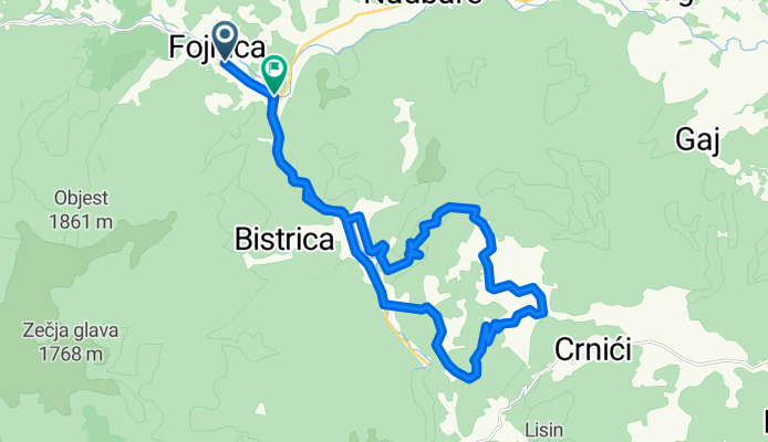
Fojnica - Bozici - Zvonigrad - Otigosce - Fojnica
A cycling route starting in Fojnica, Federation of Bosnia and Herzegovina, Bosnia and Herzegovina.
Overview
About this route
Paved route from Fojnica to Bozici village, then it turns into steep unpaved/gravel uphill section with short downhil section to Otigosce village. In Otigosce village there's a short paved section and then road turns again into unpaved/gravel all the way to Gojevici village...
- -:--
- Duration
- 27.4 km
- Distance
- 654 m
- Ascent
- 668 m
- Descent
- ---
- Avg. speed
- ---
- Avg. speed

Continue with Bikemap
Use, edit, or download this cycling route
You would like to ride Fojnica - Bozici - Zvonigrad - Otigosce - Fojnica or customize it for your own trip? Here is what you can do with this Bikemap route:
Free features
- Save this route as favorite or in collections
- Copy & plan your own version of this route
- Sync your route with Garmin or Wahoo
Premium features
Free trial for 3 days, or one-time payment. More about Bikemap Premium.
- Navigate this route on iOS & Android
- Export a GPX / KML file of this route
- Create your custom printout (try it for free)
- Download this route for offline navigation
Discover more Premium features.
Get Bikemap PremiumFrom our community
Other popular routes starting in Fojnica
 R438 to R438
- Distance
- 1.9 km
- Ascent
- 0 m
- Descent
- 0 m
- Location
- Fojnica, Federation of Bosnia and Herzegovina, Bosnia and Herzegovina
 2a. Foj - Jab
- Distance
- 112.8 km
- Ascent
- 2,707 m
- Descent
- 3,089 m
- Location
- Fojnica, Federation of Bosnia and Herzegovina, Bosnia and Herzegovina
 fojnica-prokoško jezero-sikira-vrtača
- Distance
- 52.2 km
- Ascent
- 1,742 m
- Descent
- 1,741 m
- Location
- Fojnica, Federation of Bosnia and Herzegovina, Bosnia and Herzegovina
 Restful route in
- Distance
- 8.8 km
- Ascent
- 633 m
- Descent
- 268 m
- Location
- Fojnica, Federation of Bosnia and Herzegovina, Bosnia and Herzegovina
 Ormanov potok-Fojnica-Prokoško jezero
- Distance
- 27.9 km
- Ascent
- 1,186 m
- Descent
- 122 m
- Location
- Fojnica, Federation of Bosnia and Herzegovina, Bosnia and Herzegovina
 Vranica
- Distance
- 27.4 km
- Ascent
- 1,592 m
- Descent
- 502 m
- Location
- Fojnica, Federation of Bosnia and Herzegovina, Bosnia and Herzegovina
 R438 to R438
- Distance
- 20.4 km
- Ascent
- 106 m
- Descent
- 106 m
- Location
- Fojnica, Federation of Bosnia and Herzegovina, Bosnia and Herzegovina
 Fojnica-Vrankamen-Dusina
- Distance
- 53.7 km
- Ascent
- 1,636 m
- Descent
- 1,579 m
- Location
- Fojnica, Federation of Bosnia and Herzegovina, Bosnia and Herzegovina
Open it in the app