

Szlakiem Nowohuckich fortów
A cycling route starting in Krakow, Lesser Poland Voivodeship, Poland.
Overview
About this route
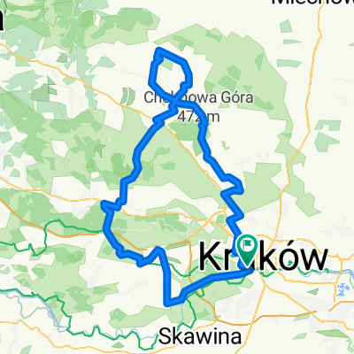
Startujemy w Krakowskim Parku Technologicznym.
Jedziemy do Batowic, gdzie wjeżdżamy na czarny szlak pieszy i <br />jedziemy nim obok fortów Sudół, Batowice, Mistrzejowice, następnie <br />kontynuujemy czarnym szlakiem rowerowym obok fortów Dłubnia, Krzesławice, <br />Grębałów, dworku Matejki. W Krzesławicach zjeżdżamy na zielony szlak <br />rowerowy i jedziemy nim aż do ulicy Klasztornej, skąd wracamy w kierunku centrum przez łąki Nowohuckie i Park Lotników Polskich
- -:--
- Duration
- 27.6 km
- Distance
- 179 m
- Ascent
- 184 m
- Descent
- ---
- Avg. speed
- ---
- Avg. speed

Route highlights
Points of interest along the route
Point of interest after 4.4 km
Cmentarz Batowicki
Point of interest after 5.5 km
Fort Sudół
Point of interest after 6.9 km
Fort Batowice
Point of interest after 9.1 km
Fort Misrzejowice
Point of interest after 12 km
Fort Dłubnia
Point of interest after 13.1 km
Fort Krzesławice
Point of interest after 14 km
Fort Grębałów
Point of interest after 16 km
Dworek Jana Matejki
Point of interest after 18.3 km
Kopiec Wandy
Point of interest after 18.7 km
Fort Mogiła
Point of interest after 20.4 km
Las Mogilski
Point of interest after 21 km
Opactwo Cystersów
Point of interest after 22.7 km
Łąki Nowohuckie
Point of interest after 26.8 km
Ogród Doświadczeń
Continue with Bikemap
Use, edit, or download this cycling route
You would like to ride Szlakiem Nowohuckich fortów or customize it for your own trip? Here is what you can do with this Bikemap route:
Free features
- Save this route as favorite or in collections
- Copy & plan your own version of this route
- Sync your route with Garmin or Wahoo
Premium features
Free trial for 3 days, or one-time payment. More about Bikemap Premium.
- Navigate this route on iOS & Android
- Export a GPX / KML file of this route
- Create your custom printout (try it for free)
- Download this route for offline navigation
Discover more Premium features.
Get Bikemap PremiumFrom our community
Other popular routes starting in Krakow
 Lasek Wolski 06.2021
- Distance
- 25.5 km
- Ascent
- 457 m
- Descent
- 456 m
- Location
- Krakow, Lesser Poland Voivodeship, Poland
 MTB Media World Cup 2018 ver_1
- Distance
- 30.3 km
- Ascent
- 591 m
- Descent
- 591 m
- Location
- Krakow, Lesser Poland Voivodeship, Poland
 Dolinki pod Krakowskie
- Distance
- 41.5 km
- Ascent
- 322 m
- Descent
- 325 m
- Location
- Krakow, Lesser Poland Voivodeship, Poland
 Krakow to Oswiecim
- Distance
- 83.1 km
- Ascent
- 162 m
- Descent
- 131 m
- Location
- Krakow, Lesser Poland Voivodeship, Poland
 Wrocławska 43B, Kraków to Poznańska 6, Kraków
- Distance
- 22.6 km
- Ascent
- 148 m
- Descent
- 192 m
- Location
- Krakow, Lesser Poland Voivodeship, Poland
 re_kreacje
- Distance
- 106.5 km
- Ascent
- 559 m
- Descent
- 564 m
- Location
- Krakow, Lesser Poland Voivodeship, Poland
 Plac Centralny - Przylasek Rusiecki
- Distance
- 13.9 km
- Ascent
- 11 m
- Descent
- 32 m
- Location
- Krakow, Lesser Poland Voivodeship, Poland
 Kraków - Katowice
- Distance
- 135.4 km
- Ascent
- 471 m
- Descent
- 414 m
- Location
- Krakow, Lesser Poland Voivodeship, Poland
Open it in the app