

EMBALSE DEL MAYES 1
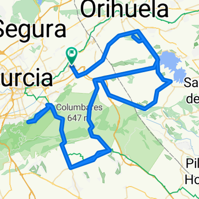
A cycling route starting in Beniel, Murcia, Spain.
Overview
About this route
ALQUERIAS, LA MACHACANTA, MURCIA, ALCANTARILLA, JAVALI NUEVO, LAS TORRES DE COTILLAS, ALGUAZAS, LAS PULLAS, CEUTI EN ROTONDA DE LOS PAJAROS A LA DERECHA, EN LA SEGUNDA ROTONDA QUE NOS ENCONTRAMOS A LA IZQUIERDA DIRECCION LA ALGAIDA, LA ALGAIDA, AV. DR. PEDRO GUILLEN A LA IZQUIERDA POR AV. MARIO SPREAFICO, A LA DERECHA POR CALLE CIUDAD DE MEXICO, ULEA, VILLANUEVA DEL RIO SEGURA, A LA DERECHA DIRECCION OJOS Y A 1,5 KLM A LA IZQUIERDA INICIANDO LA TORTUOSA SUBIDA DE 5,5 KLM AL EMBALSE DEL MAYES SALVESE QUIEN PUEDA JEJEJEJ, EN LA PRESA PARAMOS Y HACEMOS RECUENTO Y COGEMOS EL TRASVASE, CRUCE CON CRTA DE ARCHENA-YECHAR SEGUIMOS RECTO Y EN EL SIGUIENTE CRUCE A LA IZQUIERDA DIRECCION CEUTI POR CRTA B-12, CEUTI EN LA PRIMERA CALLE A LA IZQUIERDA, EN ROTONDA A LA DERECHA, EN ROTONDA DE LOS PAJAROS A LA IZQUIERDA HASTA POLIGONO BASE 2000, ROTONDA A LA DERECHA POR CRTA DE MADRID, MOLINA DE SEGURA EN TERCERA ROTONDA A LA DERECHA, TORREALTA, RIBERA DE MOLINA, RIBERA DE ABAJO, JAVALI VIEJO A LA IZQUIERDA POR CALLE CORREDERA AL FINAL A LA DERECHA POR CALLE CARRERA A LA DERECHA POR AV DE LA ÑORA, PASEO MALECON, MURCIA, GLORIETA DE ESPAÑA, PASEO TENIENTE FLOMESTA, RONDA DE GARAY, AV INTENDENTE JORGE PALACIOS, EROSKI, LA MACHACANTA, CAMINO VIEJO DE ORIHUELA, ALQUERIAS, 105,51 KLM.
- -:--
- Duration
- 105.6 km
- Distance
- 360 m
- Ascent
- 361 m
- Descent
- ---
- Avg. speed
- ---
- Avg. speed

Route quality
Waytypes & surfaces along the route
Waytypes
Busy road
70.8 km
(67 %)
Quiet road
22.5 km
(21 %)
Surfaces
Paved
22.3 km
(21 %)
Unpaved
0 km
(<1 %)
Asphalt
21.8 km
(21 %)
Paved (undefined)
0.4 km
(<1 %)
Continue with Bikemap
Use, edit, or download this cycling route
You would like to ride EMBALSE DEL MAYES 1 or customize it for your own trip? Here is what you can do with this Bikemap route:
Free features
- Save this route as favorite or in collections
- Copy & plan your own version of this route
- Sync your route with Garmin or Wahoo
Premium features
Free trial for 3 days, or one-time payment. More about Bikemap Premium.
- Navigate this route on iOS & Android
- Export a GPX / KML file of this route
- Create your custom printout (try it for free)
- Download this route for offline navigation
Discover more Premium features.
Get Bikemap PremiumFrom our community
Other popular routes starting in Beniel
 casas blancas1
- Distance
- 70.3 km
- Ascent
- 523 m
- Descent
- 524 m
- Location
- Beniel, Murcia, Spain
 SANTUARIO VIRGEN DEL ORO (ABARAN)
- Distance
- 122.4 km
- Ascent
- 601 m
- Descent
- 601 m
- Location
- Beniel, Murcia, Spain
 PUERTO FRIO POR DETRAS
- Distance
- 102.5 km
- Ascent
- 916 m
- Descent
- 917 m
- Location
- Beniel, Murcia, Spain
 ruta por la costa mediterranea
- Distance
- 111.7 km
- Ascent
- 527 m
- Descent
- 529 m
- Location
- Beniel, Murcia, Spain
 LA PINILLA
- Distance
- 140.1 km
- Ascent
- 600 m
- Descent
- 600 m
- Location
- Beniel, Murcia, Spain
 ESTACION DE BLANCA
- Distance
- 97.6 km
- Ascent
- 497 m
- Descent
- 496 m
- Location
- Beniel, Murcia, Spain
 alquerias, abanilla, macisvenda, el canton, cañada de la leña, fortuna, abanilla, alquerias
- Distance
- 92 km
- Ascent
- 1,183 m
- Descent
- 1,185 m
- Location
- Beniel, Murcia, Spain
 GENOVINOS-GARRUCHAL-CRESTA DEL GALLO-CRESTA-GARRUCHAL-GENOVINOS-ANTENAS DE HURCHILLO
- Distance
- 158.4 km
- Ascent
- 1,217 m
- Descent
- 1,218 m
- Location
- Beniel, Murcia, Spain
Open it in the app