

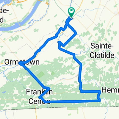
Ste- Martine / Ormstown / Mercier / Ste- Martine
A cycling route starting in Sainte-Martine, Quebec, Canada.
Overview
About this route
2014-08-23 17:24
- -:--
- Duration
- 68.5 km
- Distance
- 45 m
- Ascent
- 48 m
- Descent
- ---
- Avg. speed
- ---
- Avg. speed
Route quality
Waytypes & surfaces along the route
Waytypes
Road
58 km
(85 %)
Busy road
6 km
(9 %)
Surfaces
Paved
14.9 km
(22 %)
Asphalt
10.6 km
(15 %)
Paved (undefined)
4.3 km
(6 %)
Undefined
53.6 km
(78 %)
Continue with Bikemap
Use, edit, or download this cycling route
You would like to ride Ste- Martine / Ormstown / Mercier / Ste- Martine or customize it for your own trip? Here is what you can do with this Bikemap route:
Free features
- Save this route as favorite or in collections
- Copy & plan your own version of this route
- Sync your route with Garmin or Wahoo
Premium features
Free trial for 3 days, or one-time payment. More about Bikemap Premium.
- Navigate this route on iOS & Android
- Export a GPX / KML file of this route
- Create your custom printout (try it for free)
- Download this route for offline navigation
Discover more Premium features.
Get Bikemap PremiumFrom our community
Other popular routes starting in Sainte-Martine
 FQSC 2011 grand prix Ste-Martine
- Distance
- 10.4 km
- Ascent
- 13 m
- Descent
- 13 m
- Location
- Sainte-Martine, Quebec, Canada
 Ste-Martine / Franklin / Ste-Martine
- Distance
- 86 km
- Ascent
- 161 m
- Descent
- 160 m
- Location
- Sainte-Martine, Quebec, Canada
 Ch de la Haute-Rivière, Ste-Martine à Rue Hervé, Châteauguay
- Distance
- 5.7 km
- Ascent
- 6 m
- Descent
- 9 m
- Location
- Sainte-Martine, Quebec, Canada
 sainte martine court
- Distance
- 104 km
- Ascent
- 297 m
- Descent
- 297 m
- Location
- Sainte-Martine, Quebec, Canada
 Covey Hill, Sens anti- horaire
- Distance
- 52.8 km
- Ascent
- 326 m
- Descent
- 326 m
- Location
- Sainte-Martine, Quebec, Canada
 Covey Hill (St-Chrysostome
- Distance
- 73.7 km
- Ascent
- 417 m
- Descent
- 417 m
- Location
- Sainte-Martine, Quebec, Canada
 Circuit des bleuets
- Distance
- 75.8 km
- Ascent
- 207 m
- Descent
- 208 m
- Location
- Sainte-Martine, Quebec, Canada
 Circuit de la Rivière Châteauguay
- Distance
- 71.5 km
- Ascent
- 254 m
- Descent
- 253 m
- Location
- Sainte-Martine, Quebec, Canada
Open it in the app