
Strecke MTB R.1.1 bis R.2.3 Geländetag Möve Schmelz
A cycling route starting in Schmelz, Saarland, Germany.
Overview
About this route
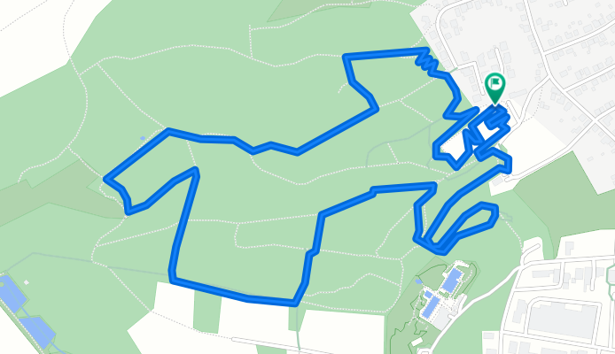
Streckenlänge 4,24km; 174hm je Runde Start auf dem Parkplatzbereich vorm Sportplatz HöhePapiercontainer; es gibt eine Startrunde die abweicht vom späteren Rundenverlauf! Ziel auf dem Sportplatz Zur Info: Strecke verläuft in entgegengesetzter Richtung zu "Cross-Strecke"
- -:--
- Duration
- 4.3 km
- Distance
- 132 m
- Ascent
- 132 m
- Descent
- ---
- Avg. speed
- ---
- Avg. speed
Continue with Bikemap
Use, edit, or download this cycling route
You would like to ride Strecke MTB R.1.1 bis R.2.3 Geländetag Möve Schmelz or customize it for your own trip? Here is what you can do with this Bikemap route:
Free features
- Save this route as favorite or in collections
- Copy & plan your own version of this route
- Sync your route with Garmin or Wahoo
Premium features
Free trial for 3 days, or one-time payment. More about Bikemap Premium.
- Navigate this route on iOS & Android
- Export a GPX / KML file of this route
- Create your custom printout (try it for free)
- Download this route for offline navigation
Discover more Premium features.
Get Bikemap PremiumFrom our community
Other popular routes starting in Schmelz
 2019 Möven geführt 31km
- Distance
- 31.3 km
- Ascent
- 418 m
- Descent
- 418 m
- Location
- Schmelz, Saarland, Germany
 Rund um Schmelz/ Hüttersdorf
- Distance
- 17.6 km
- Ascent
- 188 m
- Descent
- 190 m
- Location
- Schmelz, Saarland, Germany
 Gipfel-Trail
- Distance
- 33.9 km
- Ascent
- 509 m
- Descent
- 509 m
- Location
- Schmelz, Saarland, Germany
 Schmelzer Runde
- Distance
- 14.9 km
- Ascent
- 209 m
- Descent
- 210 m
- Location
- Schmelz, Saarland, Germany
 Rennrad-Tour zum Perterberg
- Distance
- 84.5 km
- Ascent
- 1,582 m
- Descent
- 1,583 m
- Location
- Schmelz, Saarland, Germany
 Hochwaldtrail
- Distance
- 69.7 km
- Ascent
- 767 m
- Descent
- 767 m
- Location
- Schmelz, Saarland, Germany
 schmelz-staustufe 46km 21,04,2016
- Distance
- 45.8 km
- Ascent
- 260 m
- Descent
- 258 m
- Location
- Schmelz, Saarland, Germany
 "Auf den Schaumberg"
- Distance
- 42.6 km
- Ascent
- 784 m
- Descent
- 780 m
- Location
- Schmelz, Saarland, Germany
Open it in the app