

Ziegelwald - Vögelestal - Schillertempel
A cycling route starting in Geislingen an der Steige, Baden-Württemberg, Germany.
Overview
About this route
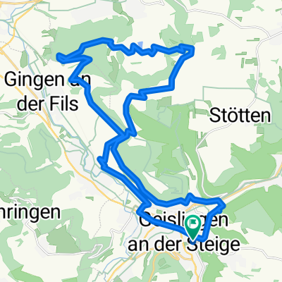
Die Strecke startet und endet am Bahnhof in Geislingen. Über die alte Weiler Steige geht es hinauf nach Weiler und auf Singeltrails und Forstwegen nach Amstetten. Dort führt die Strecke durch das Vögelestal bis zum dortigen Wanderparkplatz. Von dort links weiter Richtung Türkheim und dann hinunter ins Autal. Nachdem das Hausener Schießhaus passiert wurde, wird die B466 überquert und nach Hausen hineingefahren. Am ehemaligen Bahnhof vorbei geht es hoch in den Wald in Richtung Geislingen. Am Schillertempel vorbei führt die Strecke Richtung Oberböhringen Steige, welche man auf etwas halber Höhe erreicht. Nach der Abfahrt geht es am TVA-Gelände auf den geschotterten Weg bis zur Hinteren Siedlung von in den Zillerstall hoch zum Sängerheim. Von dort zur Wilhelmshöhe und dann auf der Straße zum Ausgangspunkt.
38 km mit ca. 800 Höhenmetern
- -:--
- Duration
- 38.2 km
- Distance
- 647 m
- Ascent
- 647 m
- Descent
- ---
- Avg. speed
- ---
- Avg. speed

Continue with Bikemap
Use, edit, or download this cycling route
You would like to ride Ziegelwald - Vögelestal - Schillertempel or customize it for your own trip? Here is what you can do with this Bikemap route:
Free features
- Save this route as favorite or in collections
- Copy & plan your own version of this route
- Sync your route with Garmin or Wahoo
Premium features
Free trial for 3 days, or one-time payment. More about Bikemap Premium.
- Navigate this route on iOS & Android
- Export a GPX / KML file of this route
- Create your custom printout (try it for free)
- Download this route for offline navigation
Discover more Premium features.
Get Bikemap PremiumFrom our community
Other popular routes starting in Geislingen an der Steige
 Albtäler Radweg
- Distance
- 186.2 km
- Ascent
- 902 m
- Descent
- 902 m
- Location
- Geislingen an der Steige, Baden-Württemberg, Germany
 geislingen
- Distance
- 22.9 km
- Ascent
- 1,268 m
- Descent
- 1,267 m
- Location
- Geislingen an der Steige, Baden-Württemberg, Germany
 Geislingen-Eselhöfe-Oppingen
- Distance
- 56 km
- Ascent
- 699 m
- Descent
- 680 m
- Location
- Geislingen an der Steige, Baden-Württemberg, Germany
 Geislingen - Kaltes Feld - Grünenberg
- Distance
- 61.9 km
- Ascent
- 859 m
- Descent
- 859 m
- Location
- Geislingen an der Steige, Baden-Württemberg, Germany
 Geislingen-Hungerbrunnental
- Distance
- 48.3 km
- Ascent
- 972 m
- Descent
- 939 m
- Location
- Geislingen an der Steige, Baden-Württemberg, Germany
 Geislingen - Ulm
- Distance
- 107.8 km
- Ascent
- 1,050 m
- Descent
- 820 m
- Location
- Geislingen an der Steige, Baden-Württemberg, Germany
 Geislingen - Fuckseck
- Distance
- 37.5 km
- Ascent
- 628 m
- Descent
- 609 m
- Location
- Geislingen an der Steige, Baden-Württemberg, Germany
 Marrenwald-Oberweckerstell
- Distance
- 26.9 km
- Ascent
- 547 m
- Descent
- 545 m
- Location
- Geislingen an der Steige, Baden-Württemberg, Germany
Open it in the app