
Zillertal-Z Aschau okruh po Zillertaler Höhenstrasse
A cycling route starting in Stumm, Tyrol, Austria.
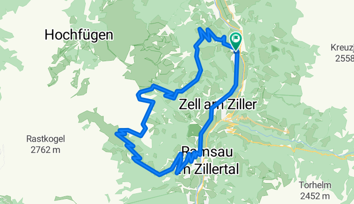
Overview
About this route
Od počátku trasy stálé stoupání 10 až 12%.Na 15.km jsme se vraceli kvůli bouřce z výšky 1906m zpět do 1860m,tam jsme přečkali bouřku v seníku.Od Melchboden je 14km klesání.Trasa vede většinou po asfaltu,jen malá část je po šotolině.
- -:--
- Duration
- 38.5 km
- Distance
- 1,481 m
- Ascent
- 1,481 m
- Descent
- ---
- Avg. speed
- ---
- Avg. speed
Route highlights
Points of interest along the route

Photo after 1.9 km
z 553m vzhůru

Photo after 2.7 km
pohled do údolí

Photo after 3.2 km
946m-stále nahoru

Photo after 6.1 km
stoupání 10-12%

Photo after 7.5 km
1455m-panorama

Photo after 9.3 km
odbočka dolů do Zell

Photo after 11.2 km
1748m-rychlost 4km/h

Photo after 11.6 km
naproti naše trasa

Photo after 11.6 km
celkový pohled

Photo after 11.7 km
v dohledu Hirschbichlalm

Photo after 11.8 km
1829m-panorama

Photo after 12 km
chata Hirschbichlalm-1840m

Photo after 14 km
poprvé nahoru před bouřkou

Photo after 15.3 km
podruhé po bouřce

Photo after 15.6 km
pohled zpět

Photo after 15.6 km
naproti Hirschbichlalm

Photo after 15.6 km
1927m-panorama

Photo after 15.6 km
pokračování trasy

Photo after 16.3 km
výhled do údolí

Photo after 17.7 km
panorama

Photo after 17.7 km
Melchboden-2017m

Photo after 17.8 km
výhled do údolí

Photo after 17.8 km
tudy 14km dolů

Photo after 20.4 km
sjezd dolů

Photo after 22.3 km
1554m-do údolí

Photo after 23.4 km
výhled na Ahornspitze

Photo after 25.7 km
1254m-panorama

Photo after 26.2 km
sjezd do Hippachu

Photo after 27.7 km
pohled do Zillertalského údolí

Photo after 37.4 km
555m-údolím po cyklostezce
Continue with Bikemap
Use, edit, or download this cycling route
You would like to ride Zillertal-Z Aschau okruh po Zillertaler Höhenstrasse or customize it for your own trip? Here is what you can do with this Bikemap route:
Free features
- Save this route as favorite or in collections
- Copy & plan your own version of this route
- Sync your route with Garmin or Wahoo
Premium features
Free trial for 3 days, or one-time payment. More about Bikemap Premium.
- Navigate this route on iOS & Android
- Export a GPX / KML file of this route
- Create your custom printout (try it for free)
- Download this route for offline navigation
Discover more Premium features.
Get Bikemap PremiumFrom our community
Other popular routes starting in Stumm
 pokus 2013_05
- Distance
- 40.3 km
- Ascent
- 1,185 m
- Descent
- 694 m
- Location
- Stumm, Tyrol, Austria
 Rondje Gerlospas
- Distance
- 164.8 km
- Ascent
- 1,937 m
- Descent
- 1,940 m
- Location
- Stumm, Tyrol, Austria
 Zillertaler Höhenstrasse CLONED FROM ROUTE 568178
- Distance
- 49.1 km
- Ascent
- 1,853 m
- Descent
- 1,853 m
- Location
- Stumm, Tyrol, Austria
 zillertalerhoehen02
- Distance
- 37 km
- Ascent
- 1,542 m
- Descent
- 1,542 m
- Location
- Stumm, Tyrol, Austria
 Finale 6. Etappe
- Distance
- 53 km
- Ascent
- 2,369 m
- Descent
- 1,441 m
- Location
- Stumm, Tyrol, Austria
 Rondje Zillertal 45km.
- Distance
- 42.9 km
- Ascent
- 1,549 m
- Descent
- 1,554 m
- Location
- Stumm, Tyrol, Austria
 Märzengrund
- Distance
- 12.4 km
- Ascent
- 1,021 m
- Descent
- 220 m
- Location
- Stumm, Tyrol, Austria
 rakousko pro upresnení
- Distance
- 38.4 km
- Ascent
- 1,496 m
- Descent
- 1,499 m
- Location
- Stumm, Tyrol, Austria
Open it in the app