

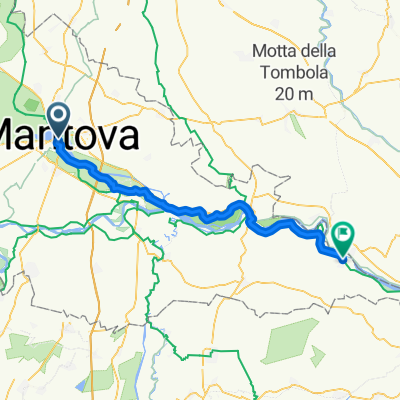
Mantova - San Benedetto Po ciclabili
A cycling route starting in Mantova, Lombardy, Italy.
Overview
About this route
Percorso utilizzando le ciclabili di Bagnolo e argini.. primo tratto ciclabile zona Pietole asfalto con dei tagli argine tratto in ghiaia Attenzione nell'attraversamento del ponte sul Po (tra l'altro danneggiato e in progetto ponte nuovo con ampia ciclabile) Tratto Mantova Bagnolo anche la exSS ha a lato una buona ciclabile (ma con vari incroci delle trasversali) da Bagnolo al ponte si possono prendere strade secondarie più dirette perché cmq poco trafficate.. una volta arrivati sugli argini del Po si può andare fino al mare a est senza problemi.. sia sponda nord che sud.. argini direzione ovest più trafficati (sono provinciali sia a nord che a sud del Po fino a Borgoforte.. (oltre non conosco)
- -:--
- Duration
- 22.3 km
- Distance
- 32 m
- Ascent
- 30 m
- Descent
- ---
- Avg. speed
- ---
- Avg. speed

Route quality
Waytypes & surfaces along the route
Waytypes
Cycleway
7.6 km
(34 %)
Track
4.5 km
(20 %)
Surfaces
Paved
11.4 km
(51 %)
Unpaved
3 km
(13 %)
Asphalt
11.4 km
(51 %)
Loose gravel
2.1 km
(9 %)
Continue with Bikemap
Use, edit, or download this cycling route
You would like to ride Mantova - San Benedetto Po ciclabili or customize it for your own trip? Here is what you can do with this Bikemap route:
Free features
- Save this route as favorite or in collections
- Copy & plan your own version of this route
- Sync your route with Garmin or Wahoo
Premium features
Free trial for 3 days, or one-time payment. More about Bikemap Premium.
- Navigate this route on iOS & Android
- Export a GPX / KML file of this route
- Create your custom printout (try it for free)
- Download this route for offline navigation
Discover more Premium features.
Get Bikemap PremiumFrom our community
Other popular routes starting in Mantova
 Mantova - Rivalta sul Mincio (ostello)
- Distance
- 11.1 km
- Ascent
- 23 m
- Descent
- 20 m
- Location
- Mantova, Lombardy, Italy
 tappa 3
- Distance
- 55.2 km
- Ascent
- 31 m
- Descent
- 43 m
- Location
- Mantova, Lombardy, Italy
 Anello Mantova- Castel d'Ario- Villimpenta
- Distance
- 63.9 km
- Ascent
- 83 m
- Descent
- 82 m
- Location
- Mantova, Lombardy, Italy
 Von Mantua bis Borgocarbonara
- Distance
- 51.8 km
- Ascent
- 97 m
- Descent
- 109 m
- Location
- Mantova, Lombardy, Italy
 20190621-Kurzroute-Mantua-Verona Hbhf.
- Distance
- 43.1 km
- Ascent
- 53 m
- Descent
- 13 m
- Location
- Mantova, Lombardy, Italy
 Mantova - riserva Bosco Fontana - Marmirolo (via Benzoni)
- Distance
- 12.2 km
- Ascent
- 31 m
- Descent
- 28 m
- Location
- Mantova, Lombardy, Italy
 Mantova percorso turistico urbano
- Distance
- 12.8 km
- Ascent
- 37 m
- Descent
- 36 m
- Location
- Mantova, Lombardy, Italy
 From Porto Mantovano to Peschiera del Garda
- Distance
- 41.6 km
- Ascent
- 127 m
- Descent
- 78 m
- Location
- Mantova, Lombardy, Italy
Open it in the app