

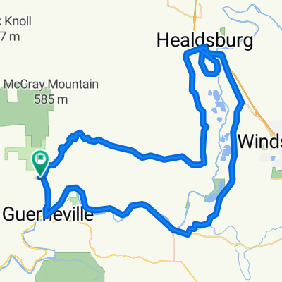
Guerneville To Bodega Bay Loop
A cycling route starting in Guerneville, California, United States of America.
Overview
About this route
This route from Guerneville to the ocean, down to Bodega bay and then inland and north via the bohemian highway was recommended to us. We have not ridden it yet, but are about to.
(cloned from route 2819475)- -:--
- Duration
- 74.3 km
- Distance
- 641 m
- Ascent
- 671 m
- Descent
- ---
- Avg. speed
- ---
- Avg. speed

Route quality
Waytypes & surfaces along the route
Waytypes
Busy road
43.7 km
(59 %)
Quiet road
16.1 km
(22 %)
Surfaces
Paved
40.3 km
(54 %)
Asphalt
40.2 km
(54 %)
Concrete
0 km
(<1 %)
Undefined
34.1 km
(46 %)
Continue with Bikemap
Use, edit, or download this cycling route
You would like to ride Guerneville To Bodega Bay Loop or customize it for your own trip? Here is what you can do with this Bikemap route:
Free features
- Save this route as favorite or in collections
- Copy & plan your own version of this route
- Sync your route with Garmin or Wahoo
Premium features
Free trial for 3 days, or one-time payment. More about Bikemap Premium.
- Navigate this route on iOS & Android
- Export a GPX / KML file of this route
- Create your custom printout (try it for free)
- Download this route for offline navigation
Discover more Premium features.
Get Bikemap PremiumFrom our community
Other popular routes starting in Guerneville
 Rio Nido3
- Distance
- 50.7 km
- Ascent
- 490 m
- Descent
- 511 m
- Location
- Guerneville, California, United States of America
 14110 Old Cazadero Rd, Guerneville to 13250 River Rd, Guerneville
- Distance
- 6 km
- Ascent
- 61 m
- Descent
- 75 m
- Location
- Guerneville, California, United States of America
 Rio Nido1
- Distance
- 77.7 km
- Ascent
- 866 m
- Descent
- 866 m
- Location
- Guerneville, California, United States of America
 Sweetwater - Westside - River
- Distance
- 40.2 km
- Ascent
- 617 m
- Descent
- 617 m
- Location
- Guerneville, California, United States of America
 Vineman 70.3 Bike Course
- Distance
- 85.7 km
- Ascent
- 442 m
- Descent
- 427 m
- Location
- Guerneville, California, United States of America
 Sweetwater - Westside - Eastside - River
- Distance
- 64.4 km
- Ascent
- 451 m
- Descent
- 451 m
- Location
- Guerneville, California, United States of America
 Guerneville to tamalpais valley
- Distance
- 127.3 km
- Ascent
- 818 m
- Descent
- 808 m
- Location
- Guerneville, California, United States of America
 14270 Highland Ave, Guerneville to 14282 Highland Ave, Guerneville
- Distance
- 23.4 km
- Ascent
- 98 m
- Descent
- 99 m
- Location
- Guerneville, California, United States of America
Open it in the app