
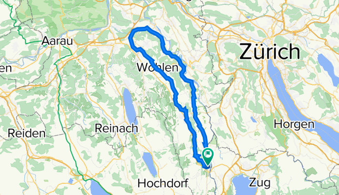
Freiaemter Veloweg
A cycling route starting in Sins, Canton of Aargau, Switzerland.
Overview
About this route
<h1> Freiaemter Veloweg</h1>
<span>Sins – Muri – Wohlen – Othmarsingen – Bremgarten – Merenschwand – Sins<br /> <br /> Länge 68 km</span><br /> <br /> Sehenswürdigkeiten unterwegs<br /> Das Freiamt ist heute ein Geheimtipp! Erfahren Sie seine kulturellen,landschaftlichen und historischen Besonderheiten: Kloster Muri, Murimoos, Bünzebene, Strohmuseum im Park in Wohlen, Auenlandschaft Reuss, Altstadt Bremgarten, Flachsee.<br /> <br /> Route<br /> Die gesamte Route ist als Freiämter Radweg signalisiert. Von der Hauptstrasse in Sins führt die Route über das Freudenbergquartier Richtung Auw – Benzenschwil ins Bünztal bei Muri und weiter über Bünzen – Wohlen – Hendschiken nach Othmarsingen. Lohnend ist nach Muri der kurze Abstecher über das Murimoos mit seinem Landwirtschaftsbetrieb, dem grossen Kinderspielplatz und der einzigartigen Storchenkolonie. Auf dem Rückweg folgen wir nach Mägenwil der Reuss über Tägerig – Niederwil – Bremgarten – Rottenschwil – Aristau – Merenschwand – Mühlau wieder nach Sins. Einstieg überall möglich, beispielsweise auch Muri- Muri<br /> <br /> - -:--
- Duration
- 68.3 km
- Distance
- 280 m
- Ascent
- 280 m
- Descent
- ---
- Avg. speed
- ---
- Avg. speed
Route quality
Waytypes & surfaces along the route
Waytypes
Quiet road
28.6 km
(42 %)
Track
12.6 km
(18 %)
Surfaces
Paved
42.4 km
(62 %)
Unpaved
2 km
(3 %)
Asphalt
33.9 km
(50 %)
Paved (undefined)
7.1 km
(10 %)
Continue with Bikemap
Use, edit, or download this cycling route
You would like to ride Freiaemter Veloweg or customize it for your own trip? Here is what you can do with this Bikemap route:
Free features
- Save this route as favorite or in collections
- Copy & plan your own version of this route
- Sync your route with Garmin or Wahoo
Premium features
Free trial for 3 days, or one-time payment. More about Bikemap Premium.
- Navigate this route on iOS & Android
- Export a GPX / KML file of this route
- Create your custom printout (try it for free)
- Download this route for offline navigation
Discover more Premium features.
Get Bikemap PremiumFrom our community
Other popular routes starting in Sins
 Kirchstrasse-Rotsee
- Distance
- 46.2 km
- Ascent
- 239 m
- Descent
- 239 m
- Location
- Sins, Canton of Aargau, Switzerland
 Karfreitagsroute
- Distance
- 108.7 km
- Ascent
- 1,323 m
- Descent
- 1,322 m
- Location
- Sins, Canton of Aargau, Switzerland
 Sattel (787m): Cham - Baar - Neuheim - Oberägeri - Raten - Rothenthurm - Sattel - Brunnen - Arth - Küssnacht - Holzhäusern - Cham (102.0Km, 1160hm)
- Distance
- 101.6 km
- Ascent
- 1,044 m
- Descent
- 1,044 m
- Location
- Sins, Canton of Aargau, Switzerland
 Feldmattweg 5, Sins nach Feldmattweg 5, Sins
- Distance
- 64.3 km
- Ascent
- 896 m
- Descent
- 896 m
- Location
- Sins, Canton of Aargau, Switzerland
 Pragelpass (1548m): Cham - Zug - Raten - Siebnen - Glarus - Pragelpass - Schwyz - Küssnacht -. Cham (166.0Km, 2330hm)
- Distance
- 166.3 km
- Ascent
- 2,023 m
- Descent
- 2,023 m
- Location
- Sins, Canton of Aargau, Switzerland
 Cham Meisterschwanden Luzern Kussnacht
- Distance
- 95.1 km
- Ascent
- 714 m
- Descent
- 701 m
- Location
- Sins, Canton of Aargau, Switzerland
 Einfache Fahrt in Bachtal
- Distance
- 8.9 km
- Ascent
- 400 m
- Descent
- 48 m
- Location
- Sins, Canton of Aargau, Switzerland
 Sonntagsrundfahrt
- Distance
- 106.2 km
- Ascent
- 888 m
- Descent
- 888 m
- Location
- Sins, Canton of Aargau, Switzerland
Open it in the app