

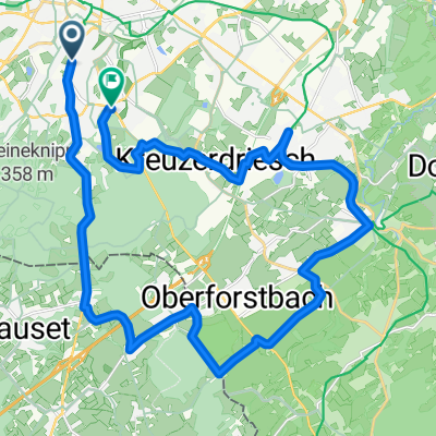
Wurmtal Radweg
A cycling route starting in Aachen, North Rhine-Westphalia, Germany.
Overview
About this route
Wurmtal Radweg
- -:--
- Duration
- 57.8 km
- Distance
- 72 m
- Ascent
- 215 m
- Descent
- ---
- Avg. speed
- ---
- Avg. speed

Route quality
Waytypes & surfaces along the route
Waytypes
Track
28.5 km
(49 %)
Path
11 km
(19 %)
Surfaces
Paved
36.5 km
(63 %)
Unpaved
14.2 km
(24 %)
Asphalt
27.3 km
(47 %)
Gravel
8.2 km
(14 %)
Route highlights
Points of interest along the route

Photo after 1.5 km
Aachen Europaplatz der Klein Wurm

Photo after 6.8 km
Wurmtal

Photo after 11.3 km
Burg Wilhemstein

Photo after 18.6 km
die Wurm

Photo after 24.1 km
Wasserschloß Zweibrüggen

Photo after 27.6 km
Geilenkirchen, kath. Pfarrkirche

Point of interest after 27.9 km
Hotel-Central/Steakhouse-Mujo Inh. Nurija Muhamedagic Konrad-Adenauer-Str. 84 52511 Geilenkirchen Telefon: +49 2451 68415 Öffnungszeiten: 12.00 - 14.30 Uhr 17.30 - 23.00 Uhr

Photo after 33.1 km
Radweg an dei Wurm

Photo after 40.8 km
poselenermuhle

Photo after 51.1 km
Würm-Mündung in die Rur

Photo after 55.8 km
"Lago-Laprello" in Heinsberg

Point of interest after 57.6 km
Bahnhof Heinsberg
Continue with Bikemap
Use, edit, or download this cycling route
You would like to ride Wurmtal Radweg or customize it for your own trip? Here is what you can do with this Bikemap route:
Free features
- Save this route as favorite or in collections
- Copy & plan your own version of this route
- Sync your route with Garmin or Wahoo
Premium features
Free trial for 3 days, or one-time payment. More about Bikemap Premium.
- Navigate this route on iOS & Android
- Export a GPX / KML file of this route
- Create your custom printout (try it for free)
- Download this route for offline navigation
Discover more Premium features.
Get Bikemap PremiumFrom our community
Other popular routes starting in Aachen
 nice MTB route
- Distance
- 21.7 km
- Ascent
- 442 m
- Descent
- 450 m
- Location
- Aachen, North Rhine-Westphalia, Germany
 Soers und Wurmtal
- Distance
- 16.1 km
- Ascent
- 145 m
- Descent
- 155 m
- Location
- Aachen, North Rhine-Westphalia, Germany
 aachen-zittau
- Distance
- 1,039.3 km
- Ascent
- 7,225 m
- Descent
- 7,135 m
- Location
- Aachen, North Rhine-Westphalia, Germany
 Köpfchen-Lichtenbusch-Vennbahn
- Distance
- 26.9 km
- Ascent
- 193 m
- Descent
- 174 m
- Location
- Aachen, North Rhine-Westphalia, Germany
 Aachen Süd, mit entspanntem Mittelstück
- Distance
- 14.5 km
- Ascent
- 257 m
- Descent
- 248 m
- Location
- Aachen, North Rhine-Westphalia, Germany
 Zweifall +Hohes Venn
- Distance
- 69.6 km
- Ascent
- 564 m
- Descent
- 564 m
- Location
- Aachen, North Rhine-Westphalia, Germany
 Trainingsrunde 3(5) 2010
- Distance
- 53 km
- Ascent
- 378 m
- Descent
- 372 m
- Location
- Aachen, North Rhine-Westphalia, Germany
 12-01-17 Kleine Mergellandrunde 47km-629hm
- Distance
- 47.5 km
- Ascent
- 473 m
- Descent
- 473 m
- Location
- Aachen, North Rhine-Westphalia, Germany
Open it in the app