
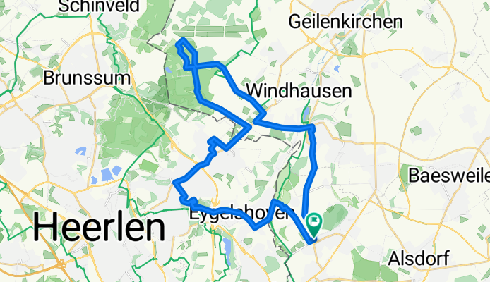
Merkstein-Landgraaf-Teverner Heide-Merkstein
A cycling route starting in Herzogenrath, North Rhine-Westphalia, Germany.
Overview
About this route
Beautiful mountain bike route from Merkstein to Landgraaf over some flowy trails. Then back to Merkstein through the Teverner Heide.
- -:--
- Duration
- 32.4 km
- Distance
- 189 m
- Ascent
- 189 m
- Descent
- ---
- Avg. speed
- ---
- Max. altitude
Route quality
Waytypes & surfaces along the route
Waytypes
Track
7.4 km
(23 %)
Path
6.2 km
(19 %)
Surfaces
Paved
11.3 km
(35 %)
Unpaved
6.8 km
(21 %)
Asphalt
10.4 km
(32 %)
Ground
2.9 km
(9 %)
Continue with Bikemap
Use, edit, or download this cycling route
You would like to ride Merkstein-Landgraaf-Teverner Heide-Merkstein or customize it for your own trip? Here is what you can do with this Bikemap route:
Free features
- Save this route as favorite or in collections
- Copy & plan your own version of this route
- Sync your route with Garmin or Wahoo
Premium features
Free trial for 3 days, or one-time payment. More about Bikemap Premium.
- Navigate this route on iOS & Android
- Export a GPX / KML file of this route
- Create your custom printout (try it for free)
- Download this route for offline navigation
Discover more Premium features.
Get Bikemap PremiumFrom our community
Other popular routes starting in Herzogenrath
 Wurmwanderroute Pley
- Distance
- 7.1 km
- Ascent
- 177 m
- Descent
- 177 m
- Location
- Herzogenrath, North Rhine-Westphalia, Germany
 Limburgs Mooiste 2010 (rode lus 150 km)
- Distance
- 152.2 km
- Ascent
- 1,078 m
- Descent
- 1,085 m
- Location
- Herzogenrath, North Rhine-Westphalia, Germany
 Testrunde Wurmtal
- Distance
- 22.8 km
- Ascent
- 689 m
- Descent
- 684 m
- Location
- Herzogenrath, North Rhine-Westphalia, Germany
 An Wurm und Broichbach
- Distance
- 28.4 km
- Ascent
- 133 m
- Descent
- 111 m
- Location
- Herzogenrath, North Rhine-Westphalia, Germany
 Merkstein-Landgraaf-Teverner Heide-Merkstein
- Distance
- 32.4 km
- Ascent
- 189 m
- Descent
- 189 m
- Location
- Herzogenrath, North Rhine-Westphalia, Germany
 Kerkrade-Aachen-K40
- Distance
- 39.4 km
- Ascent
- 260 m
- Descent
- 258 m
- Location
- Herzogenrath, North Rhine-Westphalia, Germany
 WINFOR
- Distance
- 23.3 km
- Ascent
- 110 m
- Descent
- 120 m
- Location
- Herzogenrath, North Rhine-Westphalia, Germany
 West-Bike-Tagestour
- Distance
- 74.9 km
- Ascent
- 448 m
- Descent
- 445 m
- Location
- Herzogenrath, North Rhine-Westphalia, Germany
Open it in the app